You are here: Home > Network List > TX - Texas Seismological Network Stations List
> Station FW14 Alvarado > Earthquake Result Viewer
FW14 Alvarado - Earthquake Result Viewer
| Earthquake location: |
Kuril Islands |
| Earthquake latitude/longitude: |
48.5/154.8 |
| Earthquake time(UTC): |
2018/08/10 (222) 18:12:05 GMT |
| Earthquake Depth: |
16 km |
| Earthquake Magnitude: |
5.9 Mww |
| Earthquake Catalog/Contributor: |
NEIC PDE/us |
|
| Network: |
TX Texas Seismological Network |
| Station: |
FW14 Alvarado |
| Lat/Lon: |
32.40 N/97.19 W |
| Elevation: |
219 m |
|
| Distance: |
77.1 deg |
| Az: |
55.62 deg |
| Baz: |
319.514 deg |
| Ray Param: |
0.05055793 |
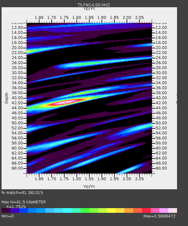
| Estimated Moho Depth: |
41.5 km |
| Estimated Crust Vp/Vs: |
1.75 |
| Assumed Crust Vp: |
6.38 km/s |
| Estimated Crust Vs: |
3.641 km/s |
| Estimated Crust Poisson's Ratio: |
0.26 |
|
| Radial Match: |
81.361015 % |
| Radial Bump: |
400 |
| Transverse Match: |
64.43765 % |
| Transverse Bump: |
400 |
| SOD ConfigId: |
2778632 |
| Insert Time: |
2018-08-24 18:19:22.042 +0000 |
| GWidth: |
2.5 |
| Max Bumps: |
400 |
| Tol: |
0.001 |
|

Signal To Noise
| Channel | StoN | STA | LTA |
| TX:FW14:00:HHZ:20180810T18:23:26.414976Z | 6.5603933 | 1.0755404E-6 | 1.6394449E-7 |
| TX:FW14:00:HH1:20180810T18:23:26.414976Z | 1.3929107 | 3.0378308E-7 | 2.1809227E-7 |
| TX:FW14:00:HH2:20180810T18:23:26.414976Z | 1.6255525 | 2.759948E-7 | 1.6978524E-7 |
| Arrivals |
| Ps | 5.0 SECOND |
| PpPs | 17 SECOND |
| PsPs/PpSs | 22 SECOND |


