You are here: Home > Network List > TX - Texas Seismological Network Stations List
> Station SN01 Snyder 1 > Earthquake Result Viewer
SN01 Snyder 1 - Earthquake Result Viewer
| Earthquake location: |
Kuril Islands |
| Earthquake latitude/longitude: |
48.5/154.8 |
| Earthquake time(UTC): |
2018/08/10 (222) 18:12:05 GMT |
| Earthquake Depth: |
16 km |
| Earthquake Magnitude: |
5.9 Mww |
| Earthquake Catalog/Contributor: |
NEIC PDE/us |
|
| Network: |
TX Texas Seismological Network |
| Station: |
SN01 Snyder 1 |
| Lat/Lon: |
32.86 N/100.89 W |
| Elevation: |
717 m |
|
| Distance: |
74.7 deg |
| Az: |
57.727 deg |
| Baz: |
318.043 deg |
| Ray Param: |
0.052166495 |
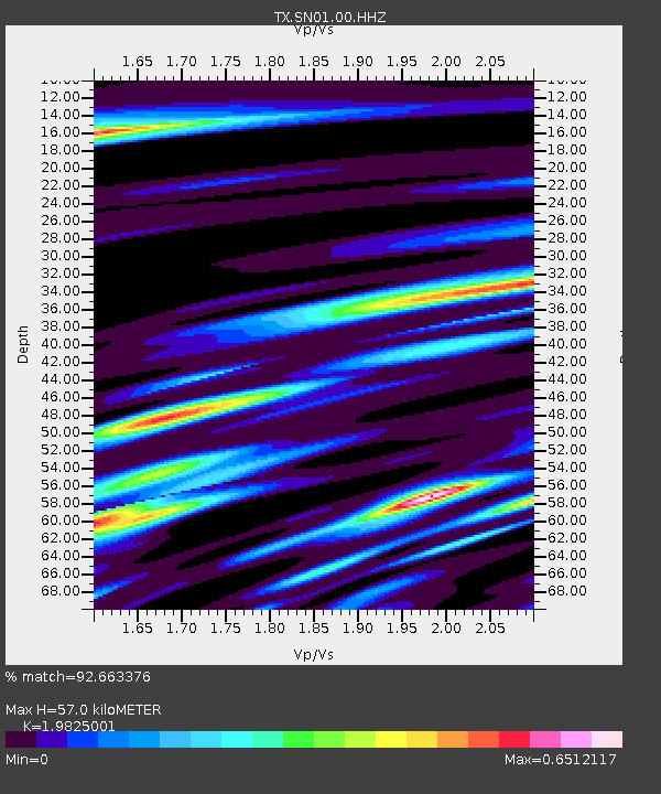
| Estimated Moho Depth: |
57.0 km |
| Estimated Crust Vp/Vs: |
1.98 |
| Assumed Crust Vp: |
6.426 km/s |
| Estimated Crust Vs: |
3.241 km/s |
| Estimated Crust Poisson's Ratio: |
0.33 |
|
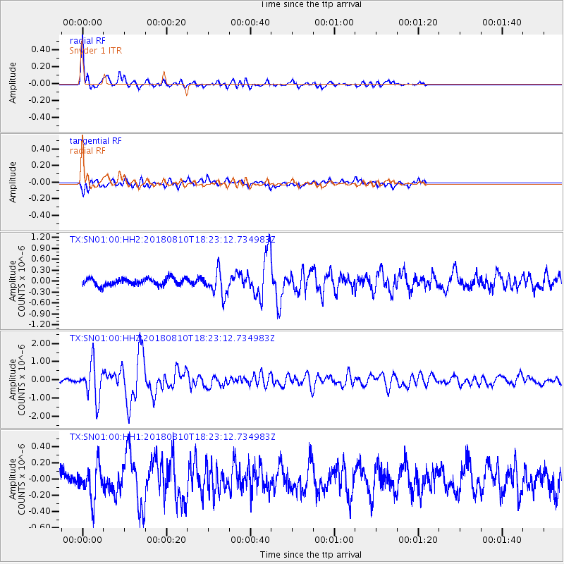
| Radial Match: |
92.663376 % |
| Radial Bump: |
355 |
| Transverse Match: |
75.602715 % |
| Transverse Bump: |
400 |
| SOD ConfigId: |
2778632 |
| Insert Time: |
2018-08-24 18:19:43.189 +0000 |
| GWidth: |
2.5 |
| Max Bumps: |
400 |
| Tol: |
0.001 |
|
Signal To Noise
| Channel | StoN | STA | LTA |
| TX:SN01:00:HHZ:20180810T18:23:12.734983Z | 14.335611 | 9.84459E-7 | 6.867227E-8 |
| TX:SN01:00:HH1:20180810T18:23:12.734983Z | 2.376542 | 2.1015164E-7 | 8.8427484E-8 |
| TX:SN01:00:HH2:20180810T18:23:12.734983Z | 3.6999707 | 3.47183E-7 | 9.383399E-8 |
| Arrivals |
| Ps | 9.0 SECOND |
| PpPs | 26 SECOND |
| PsPs/PpSs | 35 SECOND |


