You are here: Home > Network List > TX - Texas Seismological Network Stations List
> Station SN02 Snyder 2 > Earthquake Result Viewer
SN02 Snyder 2 - Earthquake Result Viewer
| Earthquake location: |
Kuril Islands |
| Earthquake latitude/longitude: |
48.5/154.8 |
| Earthquake time(UTC): |
2018/08/10 (222) 18:12:05 GMT |
| Earthquake Depth: |
16 km |
| Earthquake Magnitude: |
5.9 Mww |
| Earthquake Catalog/Contributor: |
NEIC PDE/us |
|
| Network: |
TX Texas Seismological Network |
| Station: |
SN02 Snyder 2 |
| Lat/Lon: |
32.86 N/100.91 W |
| Elevation: |
748 m |
|
| Distance: |
74.7 deg |
| Az: |
57.739 deg |
| Baz: |
318.035 deg |
| Ray Param: |
0.052176032 |
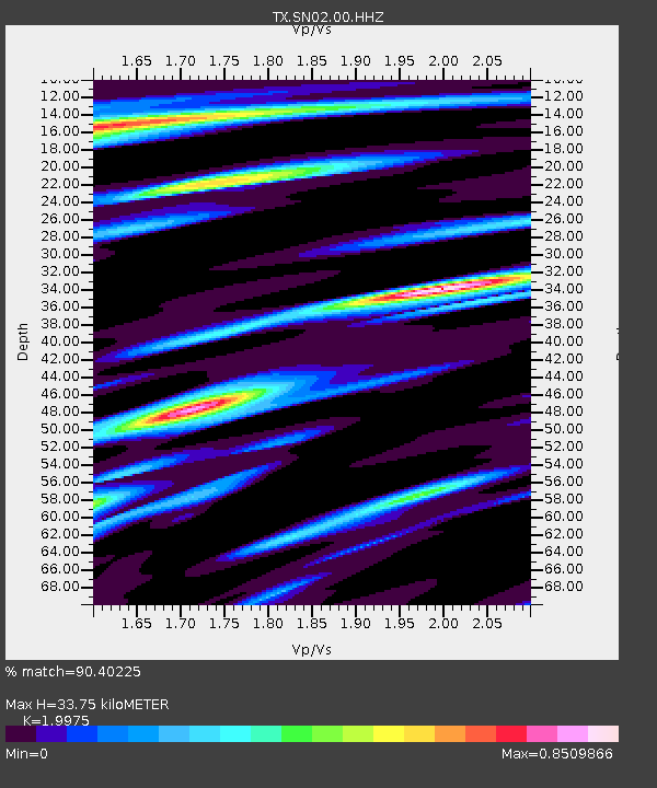
| Estimated Moho Depth: |
33.75 km |
| Estimated Crust Vp/Vs: |
2.00 |
| Assumed Crust Vp: |
6.426 km/s |
| Estimated Crust Vs: |
3.217 km/s |
| Estimated Crust Poisson's Ratio: |
0.33 |
|
| Radial Match: |
90.40225 % |
| Radial Bump: |
400 |
| Transverse Match: |
80.61713 % |
| Transverse Bump: |
400 |
| SOD ConfigId: |
2778632 |
| Insert Time: |
2018-08-24 18:19:45.432 +0000 |
| GWidth: |
2.5 |
| Max Bumps: |
400 |
| Tol: |
0.001 |
|

Signal To Noise
| Channel | StoN | STA | LTA |
| TX:SN02:00:HHZ:20180810T18:23:12.655027Z | 13.594047 | 9.699975E-7 | 7.1354584E-8 |
| TX:SN02:00:HH1:20180810T18:23:12.655027Z | 3.411496 | 3.5191212E-7 | 1.0315478E-7 |
| TX:SN02:00:HH2:20180810T18:23:12.655027Z | 1.7197791 | 2.0394376E-7 | 1.1858718E-7 |
| Arrivals |
| Ps | 5.4 SECOND |
| PpPs | 15 SECOND |
| PsPs/PpSs | 21 SECOND |


