You are here: Home > Network List > TX - Texas Seismological Network Stations List
> Station SN03 Snyder 3 > Earthquake Result Viewer
SN03 Snyder 3 - Earthquake Result Viewer
| Earthquake location: |
Kuril Islands |
| Earthquake latitude/longitude: |
48.5/154.8 |
| Earthquake time(UTC): |
2018/08/10 (222) 18:12:05 GMT |
| Earthquake Depth: |
16 km |
| Earthquake Magnitude: |
5.9 Mww |
| Earthquake Catalog/Contributor: |
NEIC PDE/us |
|
| Network: |
TX Texas Seismological Network |
| Station: |
SN03 Snyder 3 |
| Lat/Lon: |
32.92 N/100.94 W |
| Elevation: |
744 m |
|
| Distance: |
74.6 deg |
| Az: |
57.717 deg |
| Baz: |
318.013 deg |
| Ray Param: |
0.052217208 |
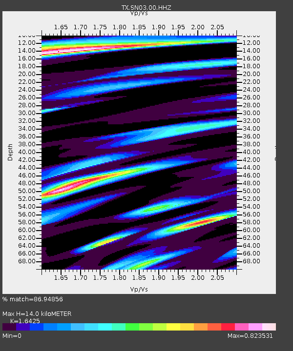
| Estimated Moho Depth: |
14.0 km |
| Estimated Crust Vp/Vs: |
1.64 |
| Assumed Crust Vp: |
6.426 km/s |
| Estimated Crust Vs: |
3.912 km/s |
| Estimated Crust Poisson's Ratio: |
0.21 |
|
| Radial Match: |
86.94856 % |
| Radial Bump: |
400 |
| Transverse Match: |
70.768715 % |
| Transverse Bump: |
400 |
| SOD ConfigId: |
2778632 |
| Insert Time: |
2018-08-24 18:19:46.967 +0000 |
| GWidth: |
2.5 |
| Max Bumps: |
400 |
| Tol: |
0.001 |
|
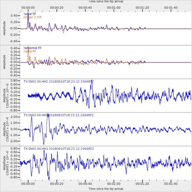
Signal To Noise
| Channel | StoN | STA | LTA |
| TX:SN03:00:HHZ:20180810T18:23:12.299985Z | 9.500947 | 9.393686E-7 | 9.887105E-8 |
| TX:SN03:00:HH1:20180810T18:23:12.299985Z | 3.776079 | 3.064843E-7 | 8.116469E-8 |
| TX:SN03:00:HH2:20180810T18:23:12.299985Z | 2.1946375 | 2.2135107E-7 | 1.00859964E-7 |
| Arrivals |
| Ps | 1.5 SECOND |
| PpPs | 5.6 SECOND |
| PsPs/PpSs | 7.0 SECOND |


