You are here: Home > Network List > XM99 - Rio Grande Seismic Transect Stations List
> Station UT51 Utah51 > Earthquake Result Viewer
UT51 Utah51 - Earthquake Result Viewer

| Earthquake location: |
South Of Panama |
| Earthquake latitude/longitude: |
6.0/-82.7 |
| Earthquake time(UTC): |
2000/12/12 (347) 05:26:45 GMT |
| Earthquake Depth: |
10 km |
| Earthquake Magnitude: |
5.8 MB, 5.7 MS, 6.3 ME, 6.1 MW |
| Earthquake Catalog/Contributor: |
WHDF/NEIC |
|
| Network: |
XM Rio Grande Seismic Transect |
| Station: |
UT51 Utah51 |
| Lat/Lon: |
37.07 N/110.00 W |
| Elevation: |
1498 m |
|
| Distance: |
39.7 deg |
| Az: |
324.94 deg |
| Baz: |
134.413 deg |
| Ray Param: |
0.07482495 |
| Estimated Moho Depth: |
28.75 km |
| Estimated Crust Vp/Vs: |
1.71 |
| Assumed Crust Vp: |
6.476 km/s |
| Estimated Crust Vs: |
3.787 km/s |
| Estimated Crust Poisson's Ratio: |
0.24 |
|
| Radial Match: |
88.069496 % |
| Radial Bump: |
291 |
| Transverse Match: |
63.609592 % |
| Transverse Bump: |
400 |
| SOD ConfigId: |
27569 |
| Insert Time: |
2010-02-26 17:27:25.918 +0000 |
| GWidth: |
2.5 |
| Max Bumps: |
400 |
| Tol: |
0.001 |
|
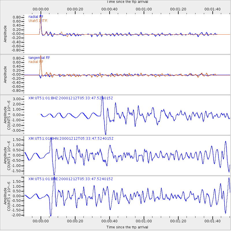
Signal To Noise
| Channel | StoN | STA | LTA |
| XM:UT51:01:BHN:20001212T05:33:47.524015Z | 1.1259301 | 1.9828533E-7 | 1.7610805E-7 |
| XM:UT51:01:BHE:20001212T05:33:47.524015Z | 0.95810694 | 1.3678327E-7 | 1.427641E-7 |
| XM:UT51:01:BHZ:20001212T05:33:47.524015Z | 0.87643665 | 2.5559982E-7 | 2.9163522E-7 |
| Arrivals |
| Ps | 3.4 SECOND |
| PpPs | 11 SECOND |
| PsPs/PpSs | 15 SECOND |


