You are here: Home > Network List > YV00 - North East Atlantic Tomography (NEAT) Stations List
> Station SKY Skye > Earthquake Result Viewer
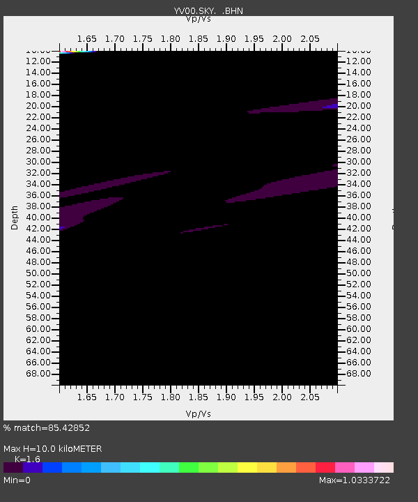
SKY Skye - Earthquake Result Viewer
| Earthquake location: |
Near Coast Of Peru |
| Earthquake latitude/longitude: |
-17.2/-72.6 |
| Earthquake time(UTC): |
2001/06/23 (174) 21:27:35 GMT |
| Earthquake Depth: |
33 km |
| Earthquake Magnitude: |
6.1 MB |
| Earthquake Catalog/Contributor: |
WHDF/NEIC |
|
| Network: |
YV North East Atlantic Tomography (NEAT) |
| Station: |
SKY Skye |
| Lat/Lon: |
57.43 N/6.67 W |
| Elevation: |
0.0 m |
|
| Distance: |
92.1 deg |
| Az: |
29.628 deg |
| Baz: |
240.891 deg |
| Ray Param: |
0.041502975 |
| Estimated Moho Depth: |
10.0 km |
| Estimated Crust Vp/Vs: |
1.60 |
| Assumed Crust Vp: |
6.24 km/s |
| Estimated Crust Vs: |
3.9 km/s |
| Estimated Crust Poisson's Ratio: |
0.18 |
|
| Radial Match: |
85.42852 % |
| Radial Bump: |
400 |
| Transverse Match: |
80.9464 % |
| Transverse Bump: |
400 |
| SOD ConfigId: |
16820 |
| Insert Time: |
2010-03-09 20:42:41.067 +0000 |
| GWidth: |
2.5 |
| Max Bumps: |
400 |
| Tol: |
0.001 |
|

Signal To Noise
| Channel | StoN | STA | LTA |
| YV:SKY: :BHN:20010623T21:40:10.22001Z | 1.0757 | 2.9092373E-5 | 2.7045062E-5 |
| YV:SKY: :BHE:20010623T21:40:10.22001Z | 3.0569787 | 4.1031268E-5 | 1.3422164E-5 |
| YV:SKY: :BHZ:20010623T21:40:10.22001Z | 1.5017762 | 8.071773E-5 | 5.3748176E-5 |
| Arrivals |
| Ps | 1.0 SECOND |
| PpPs | 4.1 SECOND |
| PsPs/PpSs | 5.1 SECOND |


