You are here: Home > Network List > YV00 - North East Atlantic Tomography (NEAT) Stations List
> Station SKY Skye > Earthquake Result Viewer
SKY Skye - Earthquake Result Viewer
| Earthquake location: |
Hindu Kush Region, Afghanistan |
| Earthquake latitude/longitude: |
36.4/70.4 |
| Earthquake time(UTC): |
2002/03/03 (062) 12:08:07 GMT |
| Earthquake Depth: |
209 km |
| Earthquake Magnitude: |
6.3 MB |
| Earthquake Catalog/Contributor: |
WHDF/NEIC |
|
| Network: |
YV North East Atlantic Tomography (NEAT) |
| Station: |
SKY Skye |
| Lat/Lon: |
57.43 N/6.67 W |
| Elevation: |
0.0 m |
|
| Distance: |
53.5 deg |
| Az: |
319.02 deg |
| Baz: |
77.909 deg |
| Ray Param: |
0.06532297 |
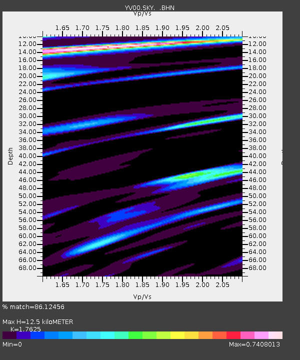
| Estimated Moho Depth: |
12.5 km |
| Estimated Crust Vp/Vs: |
1.76 |
| Assumed Crust Vp: |
6.24 km/s |
| Estimated Crust Vs: |
3.54 km/s |
| Estimated Crust Poisson's Ratio: |
0.26 |
|
| Radial Match: |
86.12456 % |
| Radial Bump: |
318 |
| Transverse Match: |
64.463196 % |
| Transverse Bump: |
400 |
| SOD ConfigId: |
16820 |
| Insert Time: |
2010-03-09 20:42:48.501 +0000 |
| GWidth: |
2.5 |
| Max Bumps: |
400 |
| Tol: |
0.001 |
|

Signal To Noise
| Channel | StoN | STA | LTA |
| YV:SKY: :BHN:20020303T12:16:36.000002Z | 1.1265384 | 3.0668673E-6 | 2.7223816E-6 |
| YV:SKY: :BHE:20020303T12:16:36.000002Z | 1.8724146 | 2.9195032E-6 | 1.5592184E-6 |
| YV:SKY: :BHZ:20020303T12:16:36.000002Z | 1.7611688 | 4.2156385E-6 | 2.3936595E-6 |
| Arrivals |
| Ps | 1.6 SECOND |
| PpPs | 5.3 SECOND |
| PsPs/PpSs | 6.9 SECOND |


