You are here: Home > Network List > TX - Texas Seismological Network Stations List
> Station RTBA Rita Blanca > Earthquake Result Viewer
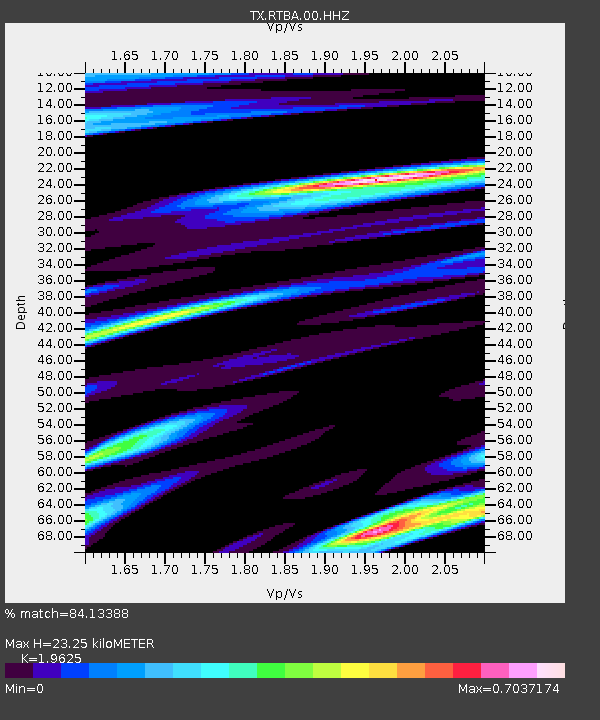
RTBA Rita Blanca - Earthquake Result Viewer
| Earthquake location: |
Kuril Islands |
| Earthquake latitude/longitude: |
48.5/154.8 |
| Earthquake time(UTC): |
2018/08/10 (222) 18:12:05 GMT |
| Earthquake Depth: |
16 km |
| Earthquake Magnitude: |
5.9 Mww |
| Earthquake Catalog/Contributor: |
NEIC PDE/us |
|
| Network: |
TX Texas Seismological Network |
| Station: |
RTBA Rita Blanca |
| Lat/Lon: |
36.44 N/102.74 W |
| Elevation: |
1284 m |
|
| Distance: |
71.0 deg |
| Az: |
56.368 deg |
| Baz: |
316.596 deg |
| Ray Param: |
0.054589335 |
| Estimated Moho Depth: |
23.25 km |
| Estimated Crust Vp/Vs: |
1.96 |
| Assumed Crust Vp: |
6.306 km/s |
| Estimated Crust Vs: |
3.213 km/s |
| Estimated Crust Poisson's Ratio: |
0.32 |
|
| Radial Match: |
84.13388 % |
| Radial Bump: |
400 |
| Transverse Match: |
72.96164 % |
| Transverse Bump: |
400 |
| SOD ConfigId: |
2778632 |
| Insert Time: |
2018-08-24 18:20:08.979 +0000 |
| GWidth: |
2.5 |
| Max Bumps: |
400 |
| Tol: |
0.001 |
|

Signal To Noise
| Channel | StoN | STA | LTA |
| TX:RTBA:00:HHZ:20180810T18:22:51.104978Z | 12.905864 | 1.0567521E-6 | 8.188155E-8 |
| TX:RTBA:00:HH1:20180810T18:22:51.104978Z | 2.6467922 | 2.6825623E-7 | 1.01351446E-7 |
| TX:RTBA:00:HH2:20180810T18:22:51.104978Z | 3.1546626 | 3.1084534E-7 | 9.853521E-8 |
| Arrivals |
| Ps | 3.7 SECOND |
| PpPs | 11 SECOND |
| PsPs/PpSs | 14 SECOND |


