You are here: Home > Network List > TX - Texas Seismological Network Stations List
> Station SMWD Samnorwood > Earthquake Result Viewer
SMWD Samnorwood - Earthquake Result Viewer
| Earthquake location: |
Kuril Islands |
| Earthquake latitude/longitude: |
48.5/154.8 |
| Earthquake time(UTC): |
2018/08/10 (222) 18:12:05 GMT |
| Earthquake Depth: |
16 km |
| Earthquake Magnitude: |
5.9 Mww |
| Earthquake Catalog/Contributor: |
NEIC PDE/us |
|
| Network: |
TX Texas Seismological Network |
| Station: |
SMWD Samnorwood |
| Lat/Lon: |
35.10 N/100.24 W |
| Elevation: |
704 m |
|
| Distance: |
73.4 deg |
| Az: |
55.753 deg |
| Baz: |
317.86 deg |
| Ray Param: |
0.053038955 |
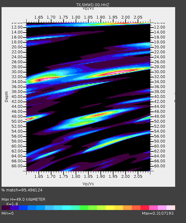
| Estimated Moho Depth: |
49.0 km |
| Estimated Crust Vp/Vs: |
1.60 |
| Assumed Crust Vp: |
6.426 km/s |
| Estimated Crust Vs: |
4.016 km/s |
| Estimated Crust Poisson's Ratio: |
0.18 |
|
| Radial Match: |
95.496124 % |
| Radial Bump: |
241 |
| Transverse Match: |
75.636734 % |
| Transverse Bump: |
400 |
| SOD ConfigId: |
2778632 |
| Insert Time: |
2018-08-24 18:20:11.610 +0000 |
| GWidth: |
2.5 |
| Max Bumps: |
400 |
| Tol: |
0.001 |
|

Signal To Noise
| Channel | StoN | STA | LTA |
| TX:SMWD:00:HHZ:20180810T18:23:05.155027Z | 20.523046 | 1.4978588E-6 | 7.2984236E-8 |
| TX:SMWD:00:HH1:20180810T18:23:05.155027Z | 13.110775 | 7.237198E-7 | 5.520038E-8 |
| TX:SMWD:00:HH2:20180810T18:23:05.155027Z | 2.781045 | 2.0471403E-7 | 7.361047E-8 |
| Arrivals |
| Ps | 4.8 SECOND |
| PpPs | 19 SECOND |
| PsPs/PpSs | 24 SECOND |


