You are here: Home > Network List > AE - Arizona Broadband Seismic Network Stations List
> Station TONTO Roosevelt/Tonto Basin > Earthquake Result Viewer
TONTO Roosevelt/Tonto Basin - Earthquake Result Viewer
| Earthquake location: |
Tonga Islands |
| Earthquake latitude/longitude: |
-18.0/-175.0 |
| Earthquake time(UTC): |
2022/06/04 (155) 13:07:25 GMT |
| Earthquake Depth: |
237 km |
| Earthquake Magnitude: |
6.3 mww |
| Earthquake Catalog/Contributor: |
NEIC PDE/us |
|
| Network: |
AE Arizona Broadband Seismic Network |
| Station: |
TONTO Roosevelt/Tonto Basin |
| Lat/Lon: |
33.65 N/111.01 W |
| Elevation: |
661 m |
|
| Distance: |
79.7 deg |
| Az: |
49.628 deg |
| Baz: |
240.382 deg |
| Ray Param: |
0.048202254 |
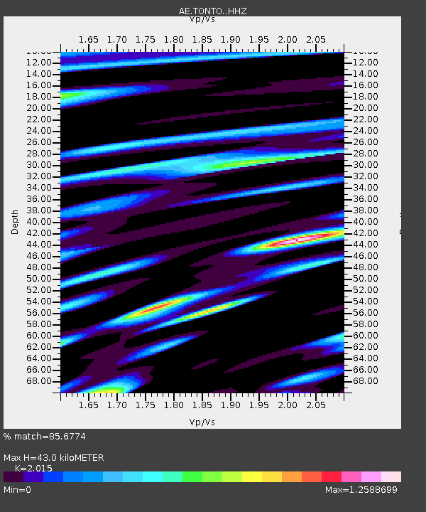
| Estimated Moho Depth: |
43.0 km |
| Estimated Crust Vp/Vs: |
2.02 |
| Assumed Crust Vp: |
6.276 km/s |
| Estimated Crust Vs: |
3.115 km/s |
| Estimated Crust Poisson's Ratio: |
0.34 |
|
| Radial Match: |
85.6774 % |
| Radial Bump: |
400 |
| Transverse Match: |
73.42218 % |
| Transverse Bump: |
400 |
| SOD ConfigId: |
28208852 |
| Insert Time: |
2022-06-27 15:10:35.766 +0000 |
| GWidth: |
2.5 |
| Max Bumps: |
400 |
| Tol: |
0.001 |
|

Signal To Noise
| Channel | StoN | STA | LTA |
| AE:TONTO: :HHZ:20220604T13:18:35.880003Z | 6.862577 | 5.481789E-7 | 7.987945E-8 |
| AE:TONTO: :HHN:20220604T13:18:35.880003Z | 1.0458364 | 1.4594228E-7 | 1.3954599E-7 |
| AE:TONTO: :HHE:20220604T13:18:35.880003Z | 1.3219217 | 1.7987516E-7 | 1.3607097E-7 |
| Arrivals |
| Ps | 7.1 SECOND |
| PpPs | 20 SECOND |
| PsPs/PpSs | 27 SECOND |


