You are here: Home > Network List > AK - Alaska Regional Network Stations List
> Station CUT Chulitna, AK, USA > Earthquake Result Viewer
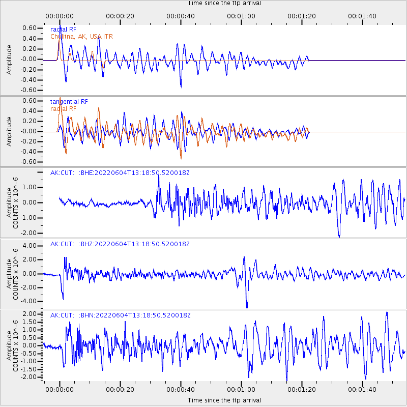
CUT Chulitna, AK, USA - Earthquake Result Viewer
| Earthquake location: |
Tonga Islands |
| Earthquake latitude/longitude: |
-18.0/-175.0 |
| Earthquake time(UTC): |
2022/06/04 (155) 13:07:25 GMT |
| Earthquake Depth: |
237 km |
| Earthquake Magnitude: |
6.3 mww |
| Earthquake Catalog/Contributor: |
NEIC PDE/us |
|
| Network: |
AK Alaska Regional Network |
| Station: |
CUT Chulitna, AK, USA |
| Lat/Lon: |
62.41 N/150.26 W |
| Elevation: |
574 m |
|
| Distance: |
82.5 deg |
| Az: |
11.322 deg |
| Baz: |
203.66 deg |
| Ray Param: |
0.046291728 |
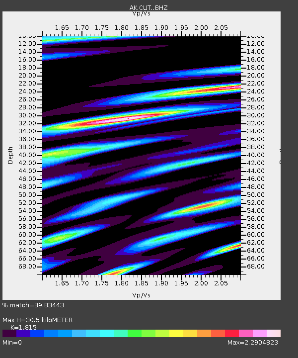
| Estimated Moho Depth: |
30.5 km |
| Estimated Crust Vp/Vs: |
1.82 |
| Assumed Crust Vp: |
6.438 km/s |
| Estimated Crust Vs: |
3.547 km/s |
| Estimated Crust Poisson's Ratio: |
0.28 |
|
| Radial Match: |
89.83443 % |
| Radial Bump: |
400 |
| Transverse Match: |
85.74628 % |
| Transverse Bump: |
372 |
| SOD ConfigId: |
28208852 |
| Insert Time: |
2022-06-27 15:11:35.617 +0000 |
| GWidth: |
2.5 |
| Max Bumps: |
400 |
| Tol: |
0.001 |
|
Signal To Noise
| Channel | StoN | STA | LTA |
| AK:CUT: :BHZ:20220604T13:18:50.520018Z | 16.207699 | 1.3476889E-6 | 8.315116E-8 |
| AK:CUT: :BHN:20220604T13:18:50.520018Z | 4.484457 | 7.539832E-7 | 1.6813256E-7 |
| AK:CUT: :BHE:20220604T13:18:50.520018Z | 4.887193 | 5.791118E-7 | 1.1849579E-7 |
| Arrivals |
| Ps | 4.0 SECOND |
| PpPs | 13 SECOND |
| PsPs/PpSs | 17 SECOND |


