You are here: Home > Network List > AK - Alaska Regional Network Stations List
> Station H16K Elim, AK, USA > Earthquake Result Viewer
H16K Elim, AK, USA - Earthquake Result Viewer
| Earthquake location: |
Tonga Islands |
| Earthquake latitude/longitude: |
-18.0/-175.0 |
| Earthquake time(UTC): |
2022/06/04 (155) 13:07:25 GMT |
| Earthquake Depth: |
237 km |
| Earthquake Magnitude: |
6.3 mww |
| Earthquake Catalog/Contributor: |
NEIC PDE/us |
|
| Network: |
AK Alaska Regional Network |
| Station: |
H16K Elim, AK, USA |
| Lat/Lon: |
64.64 N/162.24 W |
| Elevation: |
216 m |
|
| Distance: |
82.9 deg |
| Az: |
5.488 deg |
| Baz: |
192.201 deg |
| Ray Param: |
0.045960814 |
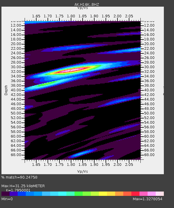
| Estimated Moho Depth: |
31.25 km |
| Estimated Crust Vp/Vs: |
1.80 |
| Assumed Crust Vp: |
6.276 km/s |
| Estimated Crust Vs: |
3.496 km/s |
| Estimated Crust Poisson's Ratio: |
0.27 |
|
| Radial Match: |
90.24758 % |
| Radial Bump: |
400 |
| Transverse Match: |
82.46226 % |
| Transverse Bump: |
400 |
| SOD ConfigId: |
28208852 |
| Insert Time: |
2022-06-27 15:12:26.076 +0000 |
| GWidth: |
2.5 |
| Max Bumps: |
400 |
| Tol: |
0.001 |
|

Signal To Noise
| Channel | StoN | STA | LTA |
| AK:H16K: :BHZ:20220604T13:18:52.919981Z | 13.891727 | 9.3441054E-7 | 6.726381E-8 |
| AK:H16K: :BHN:20220604T13:18:52.919981Z | 5.3876762 | 3.3411476E-7 | 6.201463E-8 |
| AK:H16K: :BHE:20220604T13:18:52.919981Z | 2.709058 | 2.395306E-7 | 8.841841E-8 |
| Arrivals |
| Ps | 4.1 SECOND |
| PpPs | 14 SECOND |
| PsPs/PpSs | 18 SECOND |


