You are here: Home > Network List > AK - Alaska Regional Network Stations List
> Station K13K Kusilvak Mountain, AK, USA > Earthquake Result Viewer
K13K Kusilvak Mountain, AK, USA - Earthquake Result Viewer
| Earthquake location: |
Tonga Islands |
| Earthquake latitude/longitude: |
-18.0/-175.0 |
| Earthquake time(UTC): |
2022/06/04 (155) 13:07:25 GMT |
| Earthquake Depth: |
237 km |
| Earthquake Magnitude: |
6.3 mww |
| Earthquake Catalog/Contributor: |
NEIC PDE/us |
|
| Network: |
AK Alaska Regional Network |
| Station: |
K13K Kusilvak Mountain, AK, USA |
| Lat/Lon: |
61.93 N/164.66 W |
| Elevation: |
204 m |
|
| Distance: |
80.1 deg |
| Az: |
4.932 deg |
| Baz: |
189.963 deg |
| Ray Param: |
0.04794378 |
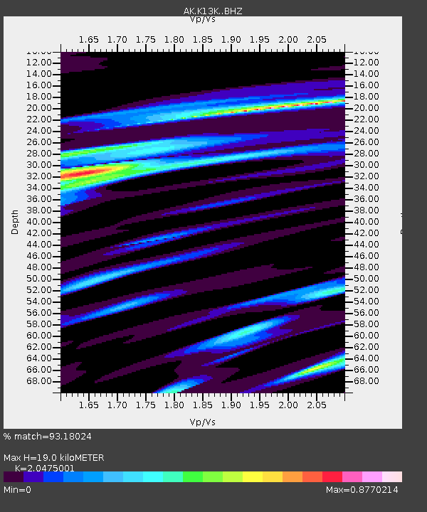
| Estimated Moho Depth: |
19.0 km |
| Estimated Crust Vp/Vs: |
2.05 |
| Assumed Crust Vp: |
6.1 km/s |
| Estimated Crust Vs: |
2.979 km/s |
| Estimated Crust Poisson's Ratio: |
0.34 |
|
| Radial Match: |
93.18024 % |
| Radial Bump: |
400 |
| Transverse Match: |
70.59553 % |
| Transverse Bump: |
400 |
| SOD ConfigId: |
28208852 |
| Insert Time: |
2022-06-27 15:12:55.695 +0000 |
| GWidth: |
2.5 |
| Max Bumps: |
400 |
| Tol: |
0.001 |
|

Signal To Noise
| Channel | StoN | STA | LTA |
| AK:K13K: :BHZ:20220604T13:18:37.960021Z | 13.881304 | 8.692756E-7 | 6.262204E-8 |
| AK:K13K: :BHN:20220604T13:18:37.960021Z | 5.827872 | 3.443883E-7 | 5.909332E-8 |
| AK:K13K: :BHE:20220604T13:18:37.960021Z | 1.210806 | 7.466217E-8 | 6.1663194E-8 |
| Arrivals |
| Ps | 3.3 SECOND |
| PpPs | 9.3 SECOND |
| PsPs/PpSs | 13 SECOND |


