You are here: Home > Network List > AK - Alaska Regional Network Stations List
> Station K20K Telida, AK, USA > Earthquake Result Viewer
K20K Telida, AK, USA - Earthquake Result Viewer
| Earthquake location: |
Tonga Islands |
| Earthquake latitude/longitude: |
-18.0/-175.0 |
| Earthquake time(UTC): |
2022/06/04 (155) 13:07:25 GMT |
| Earthquake Depth: |
237 km |
| Earthquake Magnitude: |
6.3 mww |
| Earthquake Catalog/Contributor: |
NEIC PDE/us |
|
| Network: |
AK Alaska Regional Network |
| Station: |
K20K Telida, AK, USA |
| Lat/Lon: |
63.36 N/154.07 W |
| Elevation: |
548 m |
|
| Distance: |
82.7 deg |
| Az: |
9.331 deg |
| Baz: |
200.018 deg |
| Ray Param: |
0.04612666 |
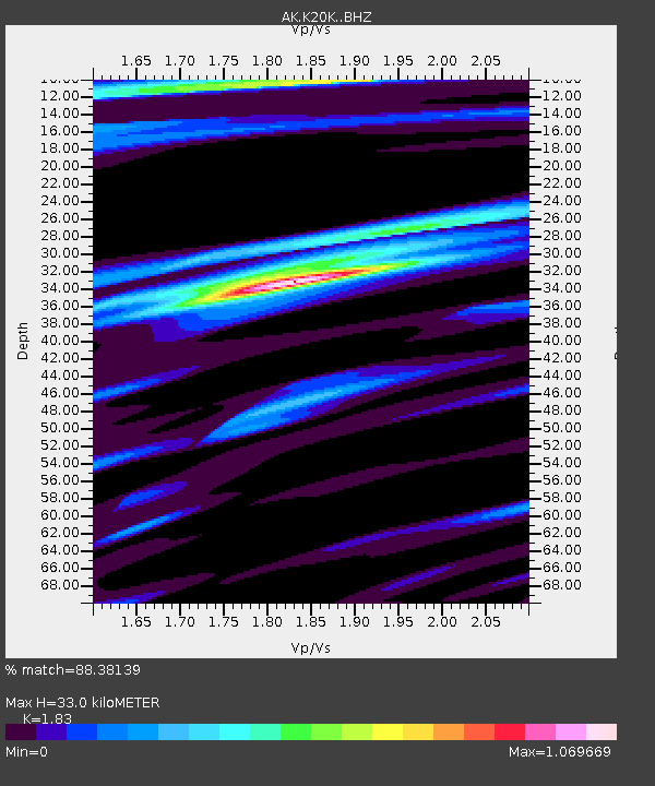
| Estimated Moho Depth: |
33.0 km |
| Estimated Crust Vp/Vs: |
1.83 |
| Assumed Crust Vp: |
6.438 km/s |
| Estimated Crust Vs: |
3.518 km/s |
| Estimated Crust Poisson's Ratio: |
0.29 |
|
| Radial Match: |
88.38139 % |
| Radial Bump: |
344 |
| Transverse Match: |
82.923164 % |
| Transverse Bump: |
383 |
| SOD ConfigId: |
28208852 |
| Insert Time: |
2022-06-27 15:12:58.734 +0000 |
| GWidth: |
2.5 |
| Max Bumps: |
400 |
| Tol: |
0.001 |
|

Signal To Noise
| Channel | StoN | STA | LTA |
| AK:K20K: :BHZ:20220604T13:18:51.72003Z | 13.250008 | 9.960671E-7 | 7.517484E-8 |
| AK:K20K: :BHN:20220604T13:18:51.72003Z | 5.5356526 | 2.6256757E-7 | 4.7432092E-8 |
| AK:K20K: :BHE:20220604T13:18:51.72003Z | 3.1553802 | 1.7953658E-7 | 5.6898557E-8 |
| Arrivals |
| Ps | 4.4 SECOND |
| PpPs | 14 SECOND |
| PsPs/PpSs | 19 SECOND |


