You are here: Home > Network List > AU - Australian Seismological Centre Stations List
> Station KIM01 GSWA station > Earthquake Result Viewer
KIM01 GSWA station - Earthquake Result Viewer
| Earthquake location: |
Tonga Islands |
| Earthquake latitude/longitude: |
-18.0/-175.0 |
| Earthquake time(UTC): |
2022/06/04 (155) 13:07:25 GMT |
| Earthquake Depth: |
237 km |
| Earthquake Magnitude: |
6.3 mww |
| Earthquake Catalog/Contributor: |
NEIC PDE/us |
|
| Network: |
AU Australian Seismological Centre |
| Station: |
KIM01 GSWA station |
| Lat/Lon: |
18.62 S/126.86 E |
| Elevation: |
314 m |
|
| Distance: |
55.0 deg |
| Az: |
259.536 deg |
| Baz: |
99.228 deg |
| Ray Param: |
0.064248405 |
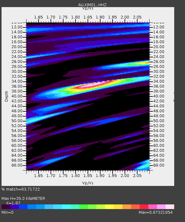
| Estimated Moho Depth: |
35.0 km |
| Estimated Crust Vp/Vs: |
1.87 |
| Assumed Crust Vp: |
6.496 km/s |
| Estimated Crust Vs: |
3.474 km/s |
| Estimated Crust Poisson's Ratio: |
0.30 |
|
| Radial Match: |
83.71722 % |
| Radial Bump: |
400 |
| Transverse Match: |
69.23969 % |
| Transverse Bump: |
400 |
| SOD ConfigId: |
28208852 |
| Insert Time: |
2022-06-27 15:16:07.354 +0000 |
| GWidth: |
2.5 |
| Max Bumps: |
400 |
| Tol: |
0.001 |
|

Signal To Noise
| Channel | StoN | STA | LTA |
| AU:KIM01: :HHZ:20220604T13:16:02.104979Z | 14.112121 | 4.791628E-6 | 3.3953987E-7 |
| AU:KIM01: :HHN:20220604T13:16:02.104979Z | 1.72963 | 6.212482E-7 | 3.591798E-7 |
| AU:KIM01: :HHE:20220604T13:16:02.104979Z | 9.991975 | 2.1916494E-6 | 2.1934096E-7 |
| Arrivals |
| Ps | 4.9 SECOND |
| PpPs | 15 SECOND |
| PsPs/PpSs | 20 SECOND |


