You are here: Home > Network List > XM99 - Rio Grande Seismic Transect Stations List
> Station UT51 Utah51 > Earthquake Result Viewer
UT51 Utah51 - Earthquake Result Viewer

| Earthquake location: |
Vanuatu Islands |
| Earthquake latitude/longitude: |
-15.4/166.9 |
| Earthquake time(UTC): |
2000/10/04 (278) 16:58:44 GMT |
| Earthquake Depth: |
23 km |
| Earthquake Magnitude: |
6.1 MB, 6.9 MS, 6.8 MW, 6.5 ME |
| Earthquake Catalog/Contributor: |
WHDF/NEIC |
|
| Network: |
XM Rio Grande Seismic Transect |
| Station: |
UT51 Utah51 |
| Lat/Lon: |
37.07 N/110.00 W |
| Elevation: |
1498 m |
|
| Distance: |
93.8 deg |
| Az: |
52.725 deg |
| Baz: |
253.646 deg |
| Ray Param: |
0.041187856 |
| Estimated Moho Depth: |
22.25 km |
| Estimated Crust Vp/Vs: |
1.71 |
| Assumed Crust Vp: |
6.476 km/s |
| Estimated Crust Vs: |
3.782 km/s |
| Estimated Crust Poisson's Ratio: |
0.24 |
|
| Radial Match: |
93.7136 % |
| Radial Bump: |
343 |
| Transverse Match: |
87.586266 % |
| Transverse Bump: |
400 |
| SOD ConfigId: |
16820 |
| Insert Time: |
2010-02-26 17:27:38.829 +0000 |
| GWidth: |
2.5 |
| Max Bumps: |
400 |
| Tol: |
0.001 |
|
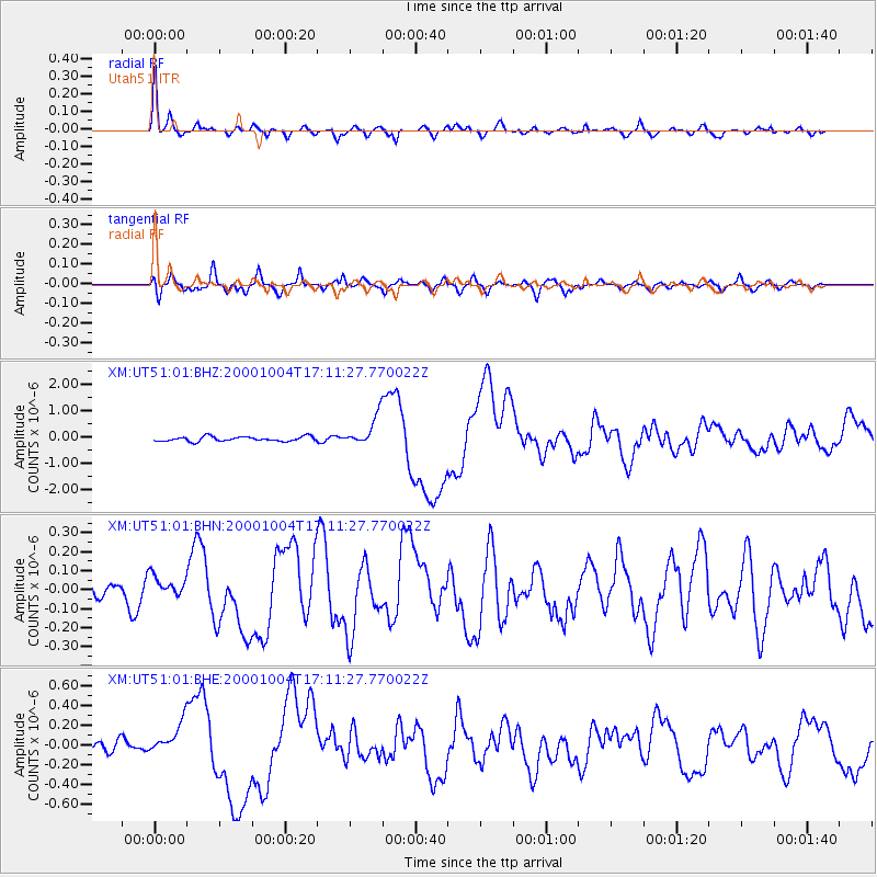
Signal To Noise
| Channel | StoN | STA | LTA |
| XM:UT51:01:BHN:20001004T17:11:27.770022Z | 1.1543884 | 6.230591E-8 | 5.397309E-8 |
| XM:UT51:01:BHE:20001004T17:11:27.770022Z | 2.3075502 | 1.629361E-7 | 7.060999E-8 |
| XM:UT51:01:BHZ:20001004T17:11:27.770022Z | 6.50209 | 5.7643365E-7 | 8.86536E-8 |
| Arrivals |
| Ps | 2.5 SECOND |
| PpPs | 9.1 SECOND |
| PsPs/PpSs | 12 SECOND |


