You are here: Home > Network List > AV - Alaska Volcano Observatory Stations List
> Station P19K Oil Pt, AK, USA > Earthquake Result Viewer
P19K Oil Pt, AK, USA - Earthquake Result Viewer
| Earthquake location: |
Tonga Islands |
| Earthquake latitude/longitude: |
-18.0/-175.0 |
| Earthquake time(UTC): |
2022/06/04 (155) 13:07:25 GMT |
| Earthquake Depth: |
237 km |
| Earthquake Magnitude: |
6.3 mww |
| Earthquake Catalog/Contributor: |
NEIC PDE/us |
|
| Network: |
AV Alaska Volcano Observatory |
| Station: |
P19K Oil Pt, AK, USA |
| Lat/Lon: |
59.65 N/153.23 W |
| Elevation: |
629 m |
|
| Distance: |
79.3 deg |
| Az: |
11.031 deg |
| Baz: |
201.019 deg |
| Ray Param: |
0.04841886 |
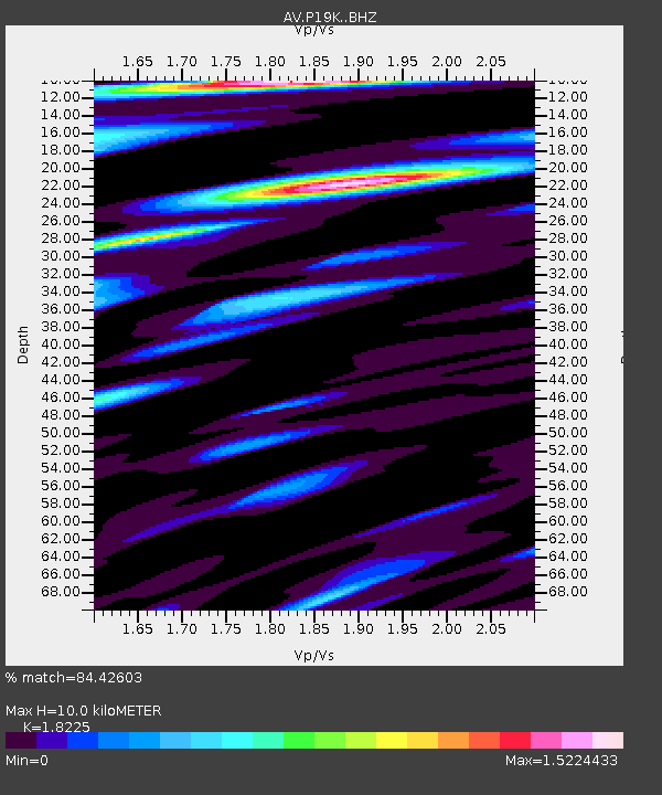
| Estimated Moho Depth: |
10.0 km |
| Estimated Crust Vp/Vs: |
1.82 |
| Assumed Crust Vp: |
5.989 km/s |
| Estimated Crust Vs: |
3.286 km/s |
| Estimated Crust Poisson's Ratio: |
0.28 |
|
| Radial Match: |
84.42603 % |
| Radial Bump: |
400 |
| Transverse Match: |
86.123245 % |
| Transverse Bump: |
400 |
| SOD ConfigId: |
28208852 |
| Insert Time: |
2022-06-27 15:18:14.508 +0000 |
| GWidth: |
2.5 |
| Max Bumps: |
400 |
| Tol: |
0.001 |
|

Signal To Noise
| Channel | StoN | STA | LTA |
| AV:P19K: :BHZ:20220604T13:18:34.224974Z | 11.2223625 | 1.4351749E-6 | 1.2788527E-7 |
| AV:P19K: :BHN:20220604T13:18:34.224974Z | 4.6580644 | 5.449088E-7 | 1.1698181E-7 |
| AV:P19K: :BHE:20220604T13:18:34.224974Z | 5.148845 | 5.29374E-7 | 1.0281412E-7 |
| Arrivals |
| Ps | 1.4 SECOND |
| PpPs | 4.6 SECOND |
| PsPs/PpSs | 6.0 SECOND |


