You are here: Home > Network List > GS - US Geological Survey Networks Stations List
> Station ASA2 ASA2 > Earthquake Result Viewer
ASA2 ASA2 - Earthquake Result Viewer
| Earthquake location: |
Tonga Islands |
| Earthquake latitude/longitude: |
-18.0/-175.0 |
| Earthquake time(UTC): |
2022/06/04 (155) 13:07:25 GMT |
| Earthquake Depth: |
237 km |
| Earthquake Magnitude: |
6.3 mww |
| Earthquake Catalog/Contributor: |
NEIC PDE/us |
|
| Network: |
GS US Geological Survey Networks |
| Station: |
ASA2 ASA2 |
| Lat/Lon: |
34.95 N/106.46 W |
| Elevation: |
1830 m |
|
| Distance: |
83.6 deg |
| Az: |
50.281 deg |
| Baz: |
243.029 deg |
| Ray Param: |
0.045501903 |
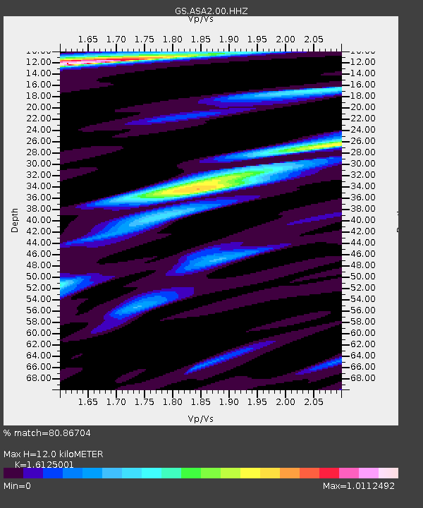
| Estimated Moho Depth: |
12.0 km |
| Estimated Crust Vp/Vs: |
1.61 |
| Assumed Crust Vp: |
6.502 km/s |
| Estimated Crust Vs: |
4.032 km/s |
| Estimated Crust Poisson's Ratio: |
0.19 |
|
| Radial Match: |
80.86704 % |
| Radial Bump: |
359 |
| Transverse Match: |
58.647198 % |
| Transverse Bump: |
349 |
| SOD ConfigId: |
28208852 |
| Insert Time: |
2022-06-27 15:27:35.511 +0000 |
| GWidth: |
2.5 |
| Max Bumps: |
400 |
| Tol: |
0.001 |
|

Signal To Noise
| Channel | StoN | STA | LTA |
| GS:ASA2:00:HHZ:20220604T13:18:56.289Z | 4.274877 | 5.014863E-7 | 1.173101E-7 |
| GS:ASA2:00:HH1:20220604T13:18:56.289Z | 2.1550543 | 1.3711124E-7 | 6.3623105E-8 |
| GS:ASA2:00:HH2:20220604T13:18:56.289Z | 3.0891247 | 1.3302866E-7 | 4.3063547E-8 |
| Arrivals |
| Ps | 1.2 SECOND |
| PpPs | 4.7 SECOND |
| PsPs/PpSs | 5.9 SECOND |


