You are here: Home > Network List > XM99 - Rio Grande Seismic Transect Stations List
> Station UT51 Utah51 > Earthquake Result Viewer
UT51 Utah51 - Earthquake Result Viewer
| Earthquake location: |
El Salvador |
| Earthquake latitude/longitude: |
13.0/-88.7 |
| Earthquake time(UTC): |
2001/01/13 (013) 17:33:32 GMT |
| Earthquake Depth: |
60 km |
| Earthquake Magnitude: |
6.4 MB, 7.8 MS, 7.7 MW, 7.5 ME |
| Earthquake Catalog/Contributor: |
WHDF/NEIC |
|
| Network: |
XM Rio Grande Seismic Transect |
| Station: |
UT51 Utah51 |
| Lat/Lon: |
37.07 N/110.00 W |
| Elevation: |
1498 m |
|
| Distance: |
30.6 deg |
| Az: |
325.144 deg |
| Baz: |
135.864 deg |
| Ray Param: |
0.079203725 |
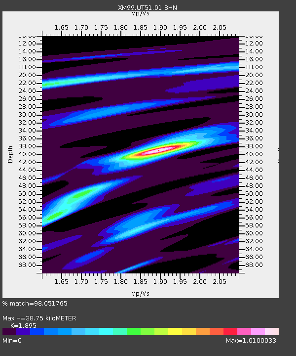
| Estimated Moho Depth: |
38.75 km |
| Estimated Crust Vp/Vs: |
1.89 |
| Assumed Crust Vp: |
6.476 km/s |
| Estimated Crust Vs: |
3.417 km/s |
| Estimated Crust Poisson's Ratio: |
0.31 |
|
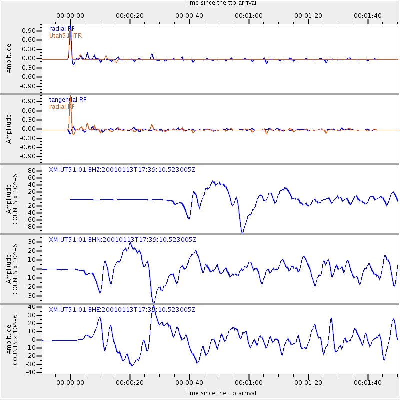
| Radial Match: |
98.051765 % |
| Radial Bump: |
186 |
| Transverse Match: |
84.18459 % |
| Transverse Bump: |
400 |
| SOD ConfigId: |
16820 |
| Insert Time: |
2010-02-26 17:27:44.262 +0000 |
| GWidth: |
2.5 |
| Max Bumps: |
400 |
| Tol: |
0.001 |
|
Signal To Noise
| Channel | StoN | STA | LTA |
| XM:UT51:01:BHN:20010113T17:39:10.523005Z | 4.114232 | 1.1205675E-6 | 2.723637E-7 |
| XM:UT51:01:BHE:20010113T17:39:10.523005Z | 3.4839582 | 1.3790522E-6 | 3.9582912E-7 |
| XM:UT51:01:BHZ:20010113T17:39:10.523005Z | 12.220584 | 2.7584101E-6 | 2.2571835E-7 |
| Arrivals |
| Ps | 5.8 SECOND |
| PpPs | 16 SECOND |
| PsPs/PpSs | 22 SECOND |


