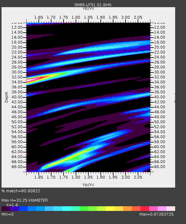
UT51 Utah51 - Earthquake Result Viewer
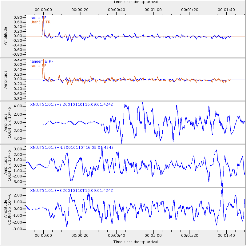
Earthquake location: Kodiak Island Region, Alaska
Earthquake latitude/longitude: 57.1/-153.2
Earthquake time(UTC): 2001/01/10 (010) 16:02:44 GMT
Earthquake Depth: 33 km
Earthquake Magnitude: 6.2 MB, 6.8 MS, 7.1 MW, 6.8 ML
Earthquake Catalog/Contributor: WHDF/NEIC
Network: XM Rio Grande Seismic Transect
Station: UT51 Utah51
Lat/Lon: 37.07 N/110.00 W
Elevation: 1498 m
Distance: 34.8 deg
Az: 106.337 deg
Baz: 319.066 deg
Ray Param: 0.07749586
Estimated Moho Depth: 33.25 km
Estimated Crust Vp/Vs: 1.60
Assumed Crust Vp: 6.476 km/s
Estimated Crust Vs: 4.047 km/s
Estimated Crust Poisson's Ratio: 0.18
Radial Match: 90.80922 %
Radial Bump: 305
Transverse Match: 64.73028 %
Transverse Bump: 400
SOD ConfigId: 16820
Insert Time: 2010-02-26 17:27:45.804 +0000
GWidth: 2.5
Max Bumps: 400
Tol: 0.001

Signal To Noise

ChannelStoNSTALTA
XM:UT51:01:BHN:20010110T16:09:01.424Z1.6378686.5830596E-74.019286E-7
XM:UT51:01:BHE:20010110T16:09:01.424Z2.5152325.471409E-72.17531E-7
XM:UT51:01:BHZ:20010110T16:09:01.424Z3.8080411.0178896E-62.6730007E-7
Arrivals
Ps3.4 SECOND
PpPs12 SECOND
PsPs/PpSs16 SECOND