You are here: Home > Network List > UU - University of Utah Regional Network Stations List
> Station KNB Kanab, UT, USA > Earthquake Result Viewer
KNB Kanab, UT, USA - Earthquake Result Viewer
| Earthquake location: |
Kuril Islands |
| Earthquake latitude/longitude: |
48.5/154.8 |
| Earthquake time(UTC): |
2018/08/10 (222) 18:12:05 GMT |
| Earthquake Depth: |
16 km |
| Earthquake Magnitude: |
5.9 Mww |
| Earthquake Catalog/Contributor: |
NEIC PDE/us |
|
| Network: |
UU University of Utah Regional Network |
| Station: |
KNB Kanab, UT, USA |
| Lat/Lon: |
37.02 N/112.82 W |
| Elevation: |
1715 m |
|
| Distance: |
64.8 deg |
| Az: |
62.066 deg |
| Baz: |
312.727 deg |
| Ray Param: |
0.058649622 |
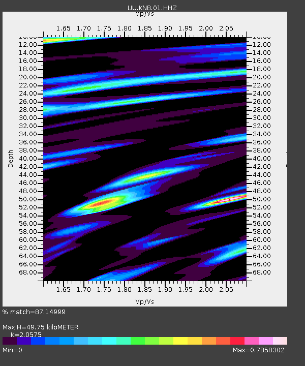
| Estimated Moho Depth: |
49.75 km |
| Estimated Crust Vp/Vs: |
2.06 |
| Assumed Crust Vp: |
6.194 km/s |
| Estimated Crust Vs: |
3.011 km/s |
| Estimated Crust Poisson's Ratio: |
0.35 |
|
| Radial Match: |
87.14999 % |
| Radial Bump: |
355 |
| Transverse Match: |
76.02953 % |
| Transverse Bump: |
368 |
| SOD ConfigId: |
2778632 |
| Insert Time: |
2018-08-24 18:22:22.096 +0000 |
| GWidth: |
2.5 |
| Max Bumps: |
400 |
| Tol: |
0.001 |
|
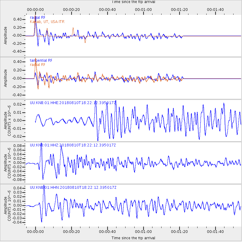
Signal To Noise
| Channel | StoN | STA | LTA |
| UU:KNB:01:HHZ:20180810T18:22:12.395017Z | 18.182924 | 4.0815877E-8 | 2.2447366E-9 |
| UU:KNB:01:HHN:20180810T18:22:12.395017Z | 5.738687 | 1.7984027E-8 | 3.1338225E-9 |
| UU:KNB:01:HHE:20180810T18:22:12.395017Z | 3.6308792 | 1.1178404E-8 | 3.0787044E-9 |
| Arrivals |
| Ps | 8.8 SECOND |
| PpPs | 24 SECOND |
| PsPs/PpSs | 33 SECOND |


