You are here: Home > Network List > XM99 - Rio Grande Seismic Transect Stations List
> Station UT51 Utah51 > Earthquake Result Viewer
UT51 Utah51 - Earthquake Result Viewer

| Earthquake location: |
Vanuatu Islands |
| Earthquake latitude/longitude: |
-14.9/167.2 |
| Earthquake time(UTC): |
2001/01/09 (009) 16:49:28 GMT |
| Earthquake Depth: |
103 km |
| Earthquake Magnitude: |
6.3 MB, 6.6 MS, 7.6 ME, 7.0 MW |
| Earthquake Catalog/Contributor: |
WHDF/NEIC |
|
| Network: |
XM Rio Grande Seismic Transect |
| Station: |
UT51 Utah51 |
| Lat/Lon: |
37.07 N/110.00 W |
| Elevation: |
1498 m |
|
| Distance: |
93.3 deg |
| Az: |
52.642 deg |
| Baz: |
253.884 deg |
| Ray Param: |
0.041236576 |
| Estimated Moho Depth: |
48.75 km |
| Estimated Crust Vp/Vs: |
1.88 |
| Assumed Crust Vp: |
6.476 km/s |
| Estimated Crust Vs: |
3.445 km/s |
| Estimated Crust Poisson's Ratio: |
0.30 |
|
| Radial Match: |
86.00648 % |
| Radial Bump: |
300 |
| Transverse Match: |
68.5327 % |
| Transverse Bump: |
400 |
| SOD ConfigId: |
16820 |
| Insert Time: |
2010-02-26 17:27:46.926 +0000 |
| GWidth: |
2.5 |
| Max Bumps: |
400 |
| Tol: |
0.001 |
|
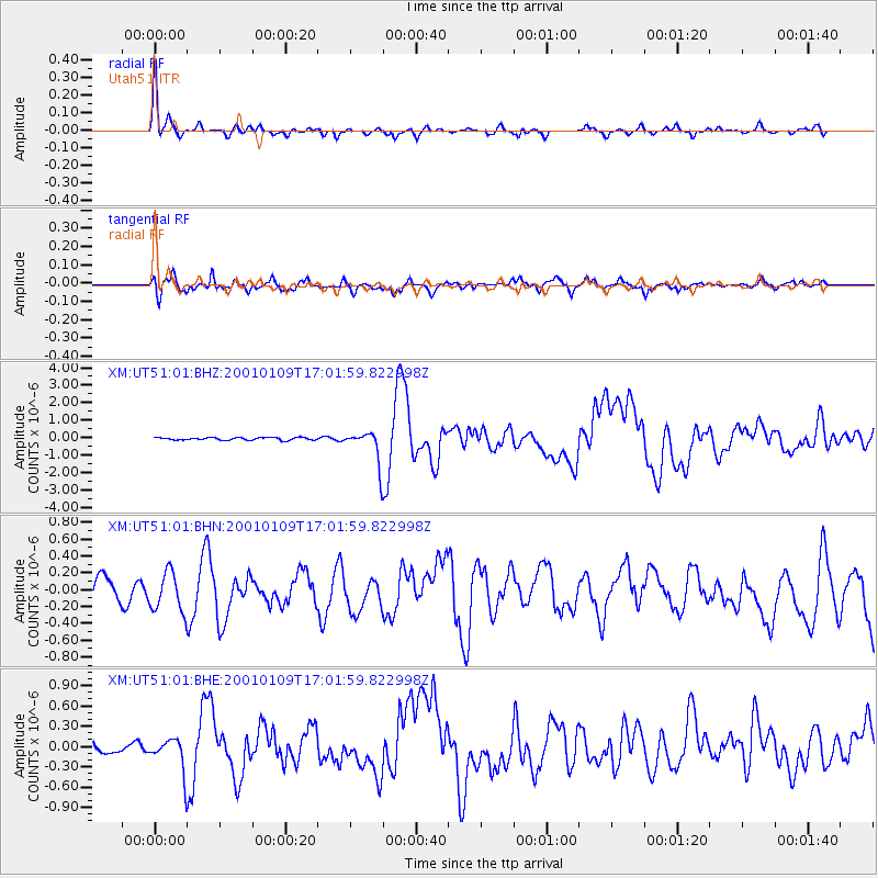
Signal To Noise
| Channel | StoN | STA | LTA |
| XM:UT51:01:BHN:20010109T17:01:59.822998Z | 1.3125613 | 2.414124E-7 | 1.8392468E-7 |
| XM:UT51:01:BHE:20010109T17:01:59.822998Z | 1.7844434 | 2.3950625E-7 | 1.3421904E-7 |
| XM:UT51:01:BHZ:20010109T17:01:59.822998Z | 12.399188 | 9.3993015E-7 | 7.580578E-8 |
| Arrivals |
| Ps | 6.8 SECOND |
| PpPs | 21 SECOND |
| PsPs/PpSs | 28 SECOND |


