You are here: Home > Network List > TX - Texas Seismological Network Stations List
> Station FW13 Cleburne > Earthquake Result Viewer
FW13 Cleburne - Earthquake Result Viewer
| Earthquake location: |
Tonga Islands |
| Earthquake latitude/longitude: |
-18.0/-175.0 |
| Earthquake time(UTC): |
2022/06/04 (155) 13:07:25 GMT |
| Earthquake Depth: |
237 km |
| Earthquake Magnitude: |
6.3 mww |
| Earthquake Catalog/Contributor: |
NEIC PDE/us |
|
| Network: |
TX Texas Seismological Network |
| Station: |
FW13 Cleburne |
| Lat/Lon: |
32.35 N/97.43 W |
| Elevation: |
259 m |
|
| Distance: |
89.4 deg |
| Az: |
55.741 deg |
| Baz: |
248.352 deg |
| Ray Param: |
0.04172039 |
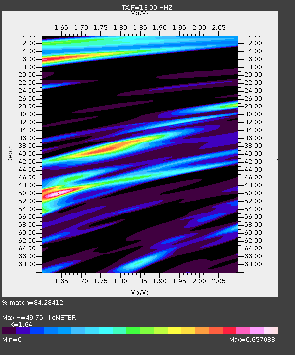
| Estimated Moho Depth: |
49.75 km |
| Estimated Crust Vp/Vs: |
1.64 |
| Assumed Crust Vp: |
6.38 km/s |
| Estimated Crust Vs: |
3.891 km/s |
| Estimated Crust Poisson's Ratio: |
0.20 |
|
| Radial Match: |
84.28412 % |
| Radial Bump: |
400 |
| Transverse Match: |
71.44149 % |
| Transverse Bump: |
387 |
| SOD ConfigId: |
28208852 |
| Insert Time: |
2022-06-27 15:38:21.150 +0000 |
| GWidth: |
2.5 |
| Max Bumps: |
400 |
| Tol: |
0.001 |
|

Signal To Noise
| Channel | StoN | STA | LTA |
| TX:FW13:00:HHZ:20220604T13:19:24.284972Z | 5.4013953 | 7.125227E-7 | 1.3191456E-7 |
| TX:FW13:00:HH1:20220604T13:19:24.284972Z | 0.92094874 | 7.447262E-8 | 8.086511E-8 |
| TX:FW13:00:HH2:20220604T13:19:24.284972Z | 1.3703017 | 1.9427269E-7 | 1.4177367E-7 |
| Arrivals |
| Ps | 5.1 SECOND |
| PpPs | 20 SECOND |
| PsPs/PpSs | 25 SECOND |


