You are here: Home > Network List > TX - Texas Seismological Network Stations List
> Station PB08 Permian Basin 08 > Earthquake Result Viewer
PB08 Permian Basin 08 - Earthquake Result Viewer
| Earthquake location: |
Tonga Islands |
| Earthquake latitude/longitude: |
-18.0/-175.0 |
| Earthquake time(UTC): |
2022/06/04 (155) 13:07:25 GMT |
| Earthquake Depth: |
237 km |
| Earthquake Magnitude: |
6.3 mww |
| Earthquake Catalog/Contributor: |
NEIC PDE/us |
|
| Network: |
TX Texas Seismological Network |
| Station: |
PB08 Permian Basin 08 |
| Lat/Lon: |
30.89 N/102.91 W |
| Elevation: |
926 m |
|
| Distance: |
84.5 deg |
| Az: |
55.246 deg |
| Baz: |
245.466 deg |
| Ray Param: |
0.044836547 |
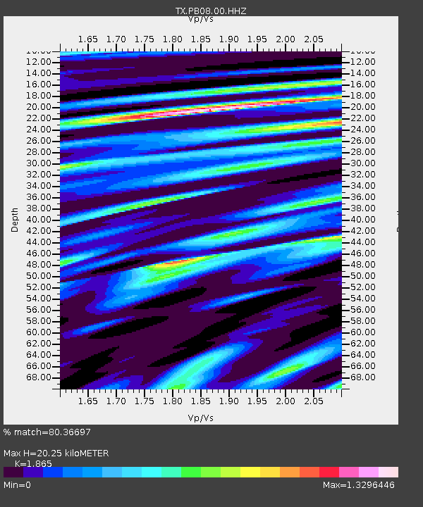
| Estimated Moho Depth: |
20.25 km |
| Estimated Crust Vp/Vs: |
1.87 |
| Assumed Crust Vp: |
6.121 km/s |
| Estimated Crust Vs: |
3.282 km/s |
| Estimated Crust Poisson's Ratio: |
0.30 |
|
| Radial Match: |
80.36697 % |
| Radial Bump: |
400 |
| Transverse Match: |
54.945568 % |
| Transverse Bump: |
400 |
| SOD ConfigId: |
28208852 |
| Insert Time: |
2022-06-27 15:38:46.574 +0000 |
| GWidth: |
2.5 |
| Max Bumps: |
400 |
| Tol: |
0.001 |
|

Signal To Noise
| Channel | StoN | STA | LTA |
| TX:PB08:00:HHZ:20220604T13:19:00.989989Z | 2.8163633 | 5.0069957E-7 | 1.7778231E-7 |
| TX:PB08:00:HH1:20220604T13:19:00.989989Z | 1.0832611 | 1.72661E-7 | 1.5939E-7 |
| TX:PB08:00:HH2:20220604T13:19:00.989989Z | 2.2269888 | 1.6100462E-7 | 7.2297E-8 |
| Arrivals |
| Ps | 2.9 SECOND |
| PpPs | 9.3 SECOND |
| PsPs/PpSs | 12 SECOND |


