You are here: Home > Network List > PF - Volcanologic Network of Piton de Fournaise-OVPF Stations List
> Station FRE Station Sismologique des Fonds de la Riviere de l'Est > Earthquake Result Viewer
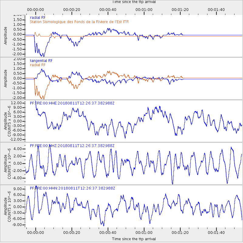
FRE Station Sismologique des Fonds de la Riviere de l'Est - Earthquake Result Viewer
*The percent match for this event was below the threshold and hence no stack was calculated.
| Earthquake location: |
West Of Macquarie Island |
| Earthquake latitude/longitude: |
-55.1/146.5 |
| Earthquake time(UTC): |
2018/08/11 (223) 12:15:36 GMT |
| Earthquake Depth: |
10 km |
| Earthquake Magnitude: |
5.4 mb |
| Earthquake Catalog/Contributor: |
NEIC PDE/us |
|
| Network: |
PF Volcanologic Network of Piton de Fournaise-OVPF |
| Station: |
FRE Station Sismologique des Fonds de la Riviere de l'Est |
| Lat/Lon: |
21.20 S/55.70 E |
| Elevation: |
1775 m |
|
| Distance: |
73.4 deg |
| Az: |
256.865 deg |
| Baz: |
143.162 deg |
| Ray Param: |
$rayparam |
*The percent match for this event was below the threshold and hence was not used in the summary stack. |
|
| Radial Match: |
54.977886 % |
| Radial Bump: |
400 |
| Transverse Match: |
51.79602 % |
| Transverse Bump: |
400 |
| SOD ConfigId: |
2778632 |
| Insert Time: |
2018-08-25 12:17:35.907 +0000 |
| GWidth: |
2.5 |
| Max Bumps: |
400 |
| Tol: |
0.001 |
|
Signal To Noise
| Channel | StoN | STA | LTA |
| PF:FRE:00:HHZ:20180811T12:26:37.382988Z | 1.1780283 | 2.6024002E-6 | 2.2091149E-6 |
| PF:FRE:00:HHN:20180811T12:26:37.382988Z | 2.8686864 | 7.1987183E-6 | 2.5094128E-6 |
| PF:FRE:00:HHE:20180811T12:26:37.382988Z | 1.7072963 | 7.597483E-6 | 4.450009E-6 |
| Arrivals |
| Ps | |
| PpPs | |
| PsPs/PpSs | |


