You are here: Home > Network List > 1E - GSC-BCOGC Induced Seismicity Study Stations List
> Station MONT4 Z > Earthquake Result Viewer
MONT4 Z - Earthquake Result Viewer
| Earthquake location: |
Rat Islands, Aleutian Islands |
| Earthquake latitude/longitude: |
52.1/178.3 |
| Earthquake time(UTC): |
2022/06/04 (155) 23:38:12 GMT |
| Earthquake Depth: |
105 km |
| Earthquake Magnitude: |
6.3 mww |
| Earthquake Catalog/Contributor: |
NEIC PDE/us |
|
| Network: |
1E GSC-BCOGC Induced Seismicity Study |
| Station: |
MONT4 Z |
| Lat/Lon: |
57.32 N/122.71 W |
| Elevation: |
1110 m |
|
| Distance: |
33.5 deg |
| Az: |
57.291 deg |
| Baz: |
286.8 deg |
| Ray Param: |
0.077864364 |
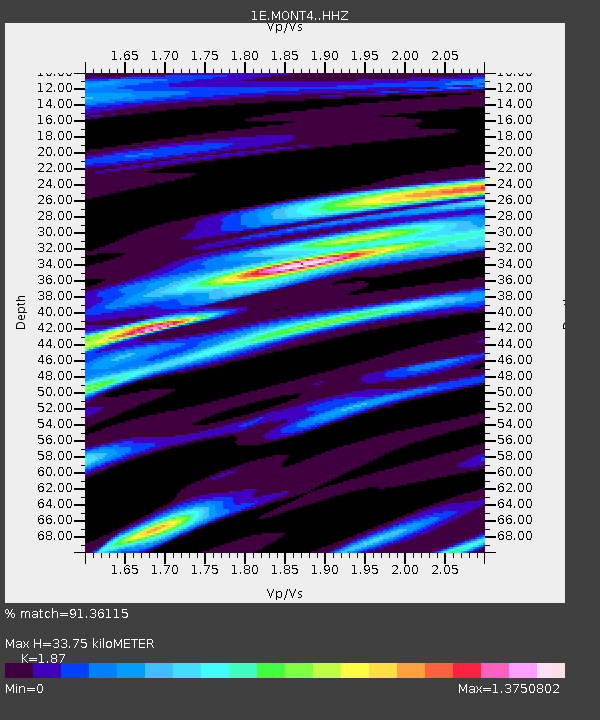
| Estimated Moho Depth: |
33.75 km |
| Estimated Crust Vp/Vs: |
1.87 |
| Assumed Crust Vp: |
6.232 km/s |
| Estimated Crust Vs: |
3.332 km/s |
| Estimated Crust Poisson's Ratio: |
0.30 |
|
| Radial Match: |
91.36115 % |
| Radial Bump: |
336 |
| Transverse Match: |
23.139593 % |
| Transverse Bump: |
400 |
| SOD ConfigId: |
28208852 |
| Insert Time: |
2022-06-27 15:50:18.958 +0000 |
| GWidth: |
2.5 |
| Max Bumps: |
400 |
| Tol: |
0.001 |
|

Signal To Noise
| Channel | StoN | STA | LTA |
| 1E:MONT4: :HHZ:20220604T23:44:11.990006Z | 19.217325 | 4.4390686E-6 | 2.3099305E-7 |
| 1E:MONT4: :HHN:20220604T23:44:11.990006Z | 1.4886463 | 3.098401E-6 | 2.081355E-6 |
| 1E:MONT4: :HHE:20220604T23:44:11.990006Z | 3.8011084 | 2.484774E-6 | 6.5369727E-7 |
| Arrivals |
| Ps | 5.0 SECOND |
| PpPs | 15 SECOND |
| PsPs/PpSs | 20 SECOND |


