You are here: Home > Network List > CO - South Carolina Seismic Network Stations List
> Station HODGE CO:HODGE > Earthquake Result Viewer
HODGE CO:HODGE - Earthquake Result Viewer
| Earthquake location: |
Northern Alaska |
| Earthquake latitude/longitude: |
69.6/-145.3 |
| Earthquake time(UTC): |
2018/08/12 (224) 14:58:54 GMT |
| Earthquake Depth: |
2.2 km |
| Earthquake Magnitude: |
6.3 ml |
| Earthquake Catalog/Contributor: |
NEIC PDE/ak |
|
| Network: |
CO South Carolina Seismic Network |
| Station: |
HODGE CO:HODGE |
| Lat/Lon: |
34.23 N/82.26 W |
| Elevation: |
151 m |
|
| Distance: |
49.0 deg |
| Az: |
101.853 deg |
| Baz: |
335.486 deg |
| Ray Param: |
0.06901462 |
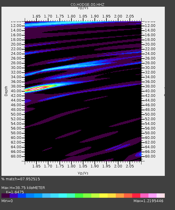
| Estimated Moho Depth: |
38.75 km |
| Estimated Crust Vp/Vs: |
1.65 |
| Assumed Crust Vp: |
6.35 km/s |
| Estimated Crust Vs: |
3.854 km/s |
| Estimated Crust Poisson's Ratio: |
0.21 |
|
| Radial Match: |
87.952515 % |
| Radial Bump: |
400 |
| Transverse Match: |
68.025665 % |
| Transverse Bump: |
400 |
| SOD ConfigId: |
2825771 |
| Insert Time: |
2018-08-26 15:00:53.021 +0000 |
| GWidth: |
2.5 |
| Max Bumps: |
400 |
| Tol: |
0.001 |
|

Signal To Noise
| Channel | StoN | STA | LTA |
| CO:HODGE:00:HHZ:20180812T15:07:11.180012Z | 17.446712 | 1.0591535E-6 | 6.070791E-8 |
| CO:HODGE:00:HHN:20180812T15:07:11.180012Z | 5.490749 | 4.7591118E-7 | 8.667509E-8 |
| CO:HODGE:00:HHE:20180812T15:07:11.180012Z | 1.2302586 | 2.2714755E-7 | 1.8463399E-7 |
| Arrivals |
| Ps | 4.2 SECOND |
| PpPs | 15 SECOND |
| PsPs/PpSs | 19 SECOND |


