You are here: Home > Network List > XM99 - Rio Grande Seismic Transect Stations List
> Station UT51 Utah51 > Earthquake Result Viewer
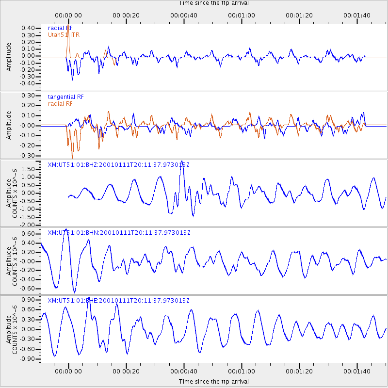
UT51 Utah51 - Earthquake Result Viewer
*The percent match for this event was below the threshold and hence no stack was calculated.
| Earthquake location: |
Fiji Islands Region |
| Earthquake latitude/longitude: |
-18.8/-176.7 |
| Earthquake time(UTC): |
2001/01/11 (011) 19:59:39 GMT |
| Earthquake Depth: |
10 km |
| Earthquake Magnitude: |
5.4 MB, 5.4 MS, 5.8 MW, 5.7 MW |
| Earthquake Catalog/Contributor: |
WHDF/NEIC |
|
| Network: |
XM Rio Grande Seismic Transect |
| Station: |
UT51 Utah51 |
| Lat/Lon: |
37.07 N/110.00 W |
| Elevation: |
1498 m |
|
| Distance: |
83.9 deg |
| Az: |
47.65 deg |
| Baz: |
241.094 deg |
| Ray Param: |
$rayparam |
*The percent match for this event was below the threshold and hence was not used in the summary stack. |
|
| Radial Match: |
80.357056 % |
| Radial Bump: |
400 |
| Transverse Match: |
50.55628 % |
| Transverse Bump: |
400 |
| SOD ConfigId: |
16820 |
| Insert Time: |
2010-02-26 17:27:57.379 +0000 |
| GWidth: |
2.5 |
| Max Bumps: |
400 |
| Tol: |
0.001 |
|
Signal To Noise
| Channel | StoN | STA | LTA |
| XM:UT51:01:BHN:20010111T20:11:37.973013Z | 1.6251149 | 4.5025237E-7 | 2.770588E-7 |
| XM:UT51:01:BHE:20010111T20:11:37.973013Z | 1.8818668 | 5.155249E-7 | 2.7394333E-7 |
| XM:UT51:01:BHZ:20010111T20:11:37.973013Z | 1.8635921 | 6.91877E-7 | 3.7125986E-7 |
| Arrivals |
| Ps | |
| PpPs | |
| PsPs/PpSs | |


