You are here: Home > Network List > CI - Caltech Regional Seismic Network Stations List
> Station SWS Sam W. Stewart, Westmorland, CA, USA > Earthquake Result Viewer
SWS Sam W. Stewart, Westmorland, CA, USA - Earthquake Result Viewer

| Earthquake location: |
Rat Islands, Aleutian Islands |
| Earthquake latitude/longitude: |
52.1/178.3 |
| Earthquake time(UTC): |
2022/06/04 (155) 23:38:12 GMT |
| Earthquake Depth: |
105 km |
| Earthquake Magnitude: |
6.3 mww |
| Earthquake Catalog/Contributor: |
NEIC PDE/us |
|
| Network: |
CI Caltech Regional Seismic Network |
| Station: |
SWS Sam W. Stewart, Westmorland, CA, USA |
| Lat/Lon: |
32.94 N/115.80 W |
| Elevation: |
140 m |
|
| Distance: |
50.4 deg |
| Az: |
85.237 deg |
| Baz: |
312.985 deg |
| Ray Param: |
0.067750484 |
| Estimated Moho Depth: |
15.0 km |
| Estimated Crust Vp/Vs: |
2.10 |
| Assumed Crust Vp: |
6.155 km/s |
| Estimated Crust Vs: |
2.934 km/s |
| Estimated Crust Poisson's Ratio: |
0.35 |
|
| Radial Match: |
89.39944 % |
| Radial Bump: |
400 |
| Transverse Match: |
81.654655 % |
| Transverse Bump: |
400 |
| SOD ConfigId: |
28208852 |
| Insert Time: |
2022-06-27 15:58:08.934 +0000 |
| GWidth: |
2.5 |
| Max Bumps: |
400 |
| Tol: |
0.001 |
|
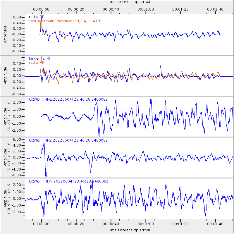
Signal To Noise
| Channel | StoN | STA | LTA |
| CI:SWS: :HHZ:20220604T23:46:28.348008Z | 17.071896 | 3.1501233E-6 | 1.84521E-7 |
| CI:SWS: :HHN:20220604T23:46:28.348008Z | 3.9976676 | 1.0294838E-6 | 2.5752112E-7 |
| CI:SWS: :HHE:20220604T23:46:28.348008Z | 4.6418257 | 1.3666585E-6 | 2.9442262E-7 |
| Arrivals |
| Ps | 2.8 SECOND |
| PpPs | 7.2 SECOND |
| PsPs/PpSs | 10 SECOND |


