You are here: Home > Network List > CN - Canadian National Seismograph Network Stations List
> Station TRQ Mont-Tremblant, QC, CA > Earthquake Result Viewer
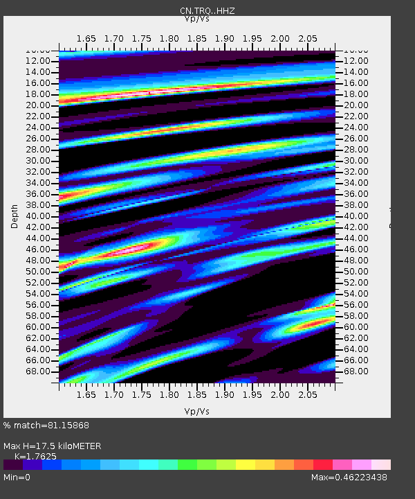
TRQ Mont-Tremblant, QC, CA - Earthquake Result Viewer
| Earthquake location: |
Rat Islands, Aleutian Islands |
| Earthquake latitude/longitude: |
52.1/178.3 |
| Earthquake time(UTC): |
2022/06/04 (155) 23:38:12 GMT |
| Earthquake Depth: |
105 km |
| Earthquake Magnitude: |
6.3 mww |
| Earthquake Catalog/Contributor: |
NEIC PDE/us |
|
| Network: |
CN Canadian National Seismograph Network |
| Station: |
TRQ Mont-Tremblant, QC, CA |
| Lat/Lon: |
46.22 N/74.55 W |
| Elevation: |
860 m |
|
| Distance: |
63.9 deg |
| Az: |
47.626 deg |
| Baz: |
318.946 deg |
| Ray Param: |
0.058980234 |
| Estimated Moho Depth: |
17.5 km |
| Estimated Crust Vp/Vs: |
1.76 |
| Assumed Crust Vp: |
6.61 km/s |
| Estimated Crust Vs: |
3.75 km/s |
| Estimated Crust Poisson's Ratio: |
0.26 |
|
| Radial Match: |
81.15868 % |
| Radial Bump: |
320 |
| Transverse Match: |
57.834183 % |
| Transverse Bump: |
400 |
| SOD ConfigId: |
28208852 |
| Insert Time: |
2022-06-27 16:00:56.836 +0000 |
| GWidth: |
2.5 |
| Max Bumps: |
400 |
| Tol: |
0.001 |
|

Signal To Noise
| Channel | StoN | STA | LTA |
| CN:TRQ: :HHZ:20220604T23:48:03.409989Z | 8.2074 | 1.5618782E-6 | 1.9030121E-7 |
| CN:TRQ: :HHN:20220604T23:48:03.409989Z | 3.6379888 | 4.634284E-7 | 1.2738587E-7 |
| CN:TRQ: :HHE:20220604T23:48:03.409989Z | 5.359901 | 5.3654344E-7 | 1.0010324E-7 |
| Arrivals |
| Ps | 2.1 SECOND |
| PpPs | 7.0 SECOND |
| PsPs/PpSs | 9.1 SECOND |


