You are here: Home > Network List > GB - Great Britain Seismograph Network Stations List
> Station INVG INVERGELDIE , ENGLAND > Earthquake Result Viewer
INVG INVERGELDIE , ENGLAND - Earthquake Result Viewer
| Earthquake location: |
Rat Islands, Aleutian Islands |
| Earthquake latitude/longitude: |
52.1/178.3 |
| Earthquake time(UTC): |
2022/06/04 (155) 23:38:12 GMT |
| Earthquake Depth: |
105 km |
| Earthquake Magnitude: |
6.3 mww |
| Earthquake Catalog/Contributor: |
NEIC PDE/us |
|
| Network: |
GB Great Britain Seismograph Network |
| Station: |
INVG INVERGELDIE , ENGLAND |
| Lat/Lon: |
56.43 N/4.04 W |
| Elevation: |
279 m |
|
| Distance: |
71.9 deg |
| Az: |
1.371 deg |
| Baz: |
358.477 deg |
| Ray Param: |
0.05379695 |
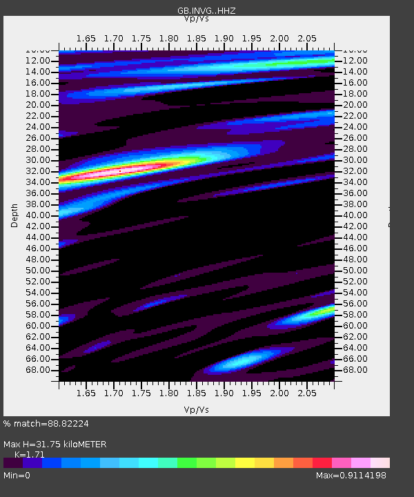
| Estimated Moho Depth: |
31.75 km |
| Estimated Crust Vp/Vs: |
1.71 |
| Assumed Crust Vp: |
6.276 km/s |
| Estimated Crust Vs: |
3.67 km/s |
| Estimated Crust Poisson's Ratio: |
0.24 |
|
| Radial Match: |
88.82224 % |
| Radial Bump: |
400 |
| Transverse Match: |
80.83616 % |
| Transverse Bump: |
400 |
| SOD ConfigId: |
28208852 |
| Insert Time: |
2022-06-27 16:03:02.495 +0000 |
| GWidth: |
2.5 |
| Max Bumps: |
400 |
| Tol: |
0.001 |
|

Signal To Noise
| Channel | StoN | STA | LTA |
| GB:INVG: :HHZ:20220604T23:48:53.039994Z | 6.1012697 | 1.4842601E-7 | 2.4327068E-8 |
| GB:INVG: :HHN:20220604T23:48:53.039994Z | 1.9850241 | 4.035252E-8 | 2.0328478E-8 |
| GB:INVG: :HHE:20220604T23:48:53.039994Z | 1.3210607 | 1.7310182E-8 | 1.3103245E-8 |
| Arrivals |
| Ps | 3.7 SECOND |
| PpPs | 13 SECOND |
| PsPs/PpSs | 17 SECOND |


