You are here: Home > Network List > G - GEOSCOPE Stations List
> Station CLF Chambon la Foret observatory, France > Earthquake Result Viewer
CLF Chambon la Foret observatory, France - Earthquake Result Viewer

| Earthquake location: |
Northern Alaska |
| Earthquake latitude/longitude: |
69.6/-145.3 |
| Earthquake time(UTC): |
2018/08/12 (224) 14:58:54 GMT |
| Earthquake Depth: |
2.2 km |
| Earthquake Magnitude: |
6.3 ml |
| Earthquake Catalog/Contributor: |
NEIC PDE/ak |
|
| Network: |
G GEOSCOPE |
| Station: |
CLF Chambon la Foret observatory, France |
| Lat/Lon: |
48.03 N/2.26 E |
| Elevation: |
145 m |
|
| Distance: |
60.3 deg |
| Az: |
24.482 deg |
| Baz: |
347.476 deg |
| Ray Param: |
0.061620604 |
| Estimated Moho Depth: |
33.75 km |
| Estimated Crust Vp/Vs: |
1.81 |
| Assumed Crust Vp: |
6.12 km/s |
| Estimated Crust Vs: |
3.386 km/s |
| Estimated Crust Poisson's Ratio: |
0.28 |
|
| Radial Match: |
87.9945 % |
| Radial Bump: |
400 |
| Transverse Match: |
78.04629 % |
| Transverse Bump: |
400 |
| SOD ConfigId: |
2825771 |
| Insert Time: |
2018-08-26 15:01:36.494 +0000 |
| GWidth: |
2.5 |
| Max Bumps: |
400 |
| Tol: |
0.001 |
|
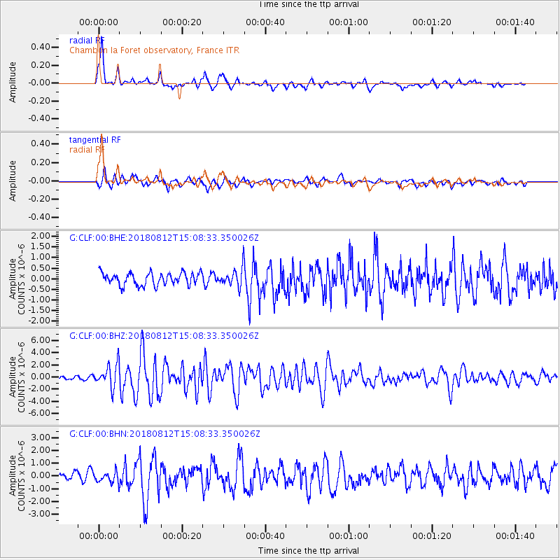
Signal To Noise
| Channel | StoN | STA | LTA |
| G:CLF:00:BHZ:20180812T15:08:33.350026Z | 9.388271 | 1.9558852E-6 | 2.0833285E-7 |
| G:CLF:00:BHN:20180812T15:08:33.350026Z | 1.5879215 | 4.215083E-7 | 2.6544657E-7 |
| G:CLF:00:BHE:20180812T15:08:33.350026Z | 1.566564 | 4.4878504E-7 | 2.864773E-7 |
| Arrivals |
| Ps | 4.6 SECOND |
| PpPs | 15 SECOND |
| PsPs/PpSs | 19 SECOND |


