You are here: Home > Network List > GM - US Geological Survey Networks Stations List
> Station NMP35 New Mexico Permian - Site# W3S5 > Earthquake Result Viewer
NMP35 New Mexico Permian - Site# W3S5 - Earthquake Result Viewer
| Earthquake location: |
Rat Islands, Aleutian Islands |
| Earthquake latitude/longitude: |
52.1/178.3 |
| Earthquake time(UTC): |
2022/06/04 (155) 23:38:12 GMT |
| Earthquake Depth: |
105 km |
| Earthquake Magnitude: |
6.3 mww |
| Earthquake Catalog/Contributor: |
NEIC PDE/us |
|
| Network: |
GM US Geological Survey Networks |
| Station: |
NMP35 New Mexico Permian - Site# W3S5 |
| Lat/Lon: |
32.35 N/103.72 W |
| Elevation: |
1071 m |
|
| Distance: |
58.1 deg |
| Az: |
77.074 deg |
| Baz: |
314.699 deg |
| Ray Param: |
0.062716305 |
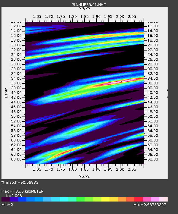
| Estimated Moho Depth: |
35.0 km |
| Estimated Crust Vp/Vs: |
2.01 |
| Assumed Crust Vp: |
6.129 km/s |
| Estimated Crust Vs: |
3.057 km/s |
| Estimated Crust Poisson's Ratio: |
0.33 |
|
| Radial Match: |
90.06983 % |
| Radial Bump: |
400 |
| Transverse Match: |
48.214035 % |
| Transverse Bump: |
400 |
| SOD ConfigId: |
28208852 |
| Insert Time: |
2022-06-27 16:04:06.087 +0000 |
| GWidth: |
2.5 |
| Max Bumps: |
400 |
| Tol: |
0.001 |
|

Signal To Noise
| Channel | StoN | STA | LTA |
| GM:NMP35:01:HHZ:20220604T23:47:24.519974Z | 11.71548 | 2.1720891E-6 | 1.8540335E-7 |
| GM:NMP35:01:HHN:20220604T23:47:24.519974Z | 6.7450438 | 6.4898046E-7 | 9.62159E-8 |
| GM:NMP35:01:HHE:20220604T23:47:24.519974Z | 3.0742102 | 5.304817E-7 | 1.725587E-7 |
| Arrivals |
| Ps | 6.0 SECOND |
| PpPs | 17 SECOND |
| PsPs/PpSs | 22 SECOND |


