You are here: Home > Network List > G - GEOSCOPE Stations List
> Station MPG Montagne des Peres, French Guyana > Earthquake Result Viewer
MPG Montagne des Peres, French Guyana - Earthquake Result Viewer
| Earthquake location: |
Northern Alaska |
| Earthquake latitude/longitude: |
69.6/-145.3 |
| Earthquake time(UTC): |
2018/08/12 (224) 14:58:54 GMT |
| Earthquake Depth: |
2.2 km |
| Earthquake Magnitude: |
6.3 ml |
| Earthquake Catalog/Contributor: |
NEIC PDE/ak |
|
| Network: |
G GEOSCOPE |
| Station: |
MPG Montagne des Peres, French Guyana |
| Lat/Lon: |
5.11 N/52.64 W |
| Elevation: |
147 m |
|
| Distance: |
86.2 deg |
| Az: |
85.73 deg |
| Baz: |
339.411 deg |
| Ray Param: |
0.04424849 |
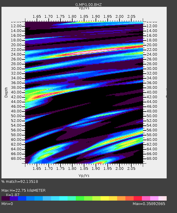
| Estimated Moho Depth: |
22.75 km |
| Estimated Crust Vp/Vs: |
1.87 |
| Assumed Crust Vp: |
6.472 km/s |
| Estimated Crust Vs: |
3.461 km/s |
| Estimated Crust Poisson's Ratio: |
0.30 |
|
| Radial Match: |
92.13518 % |
| Radial Bump: |
400 |
| Transverse Match: |
85.833275 % |
| Transverse Bump: |
400 |
| SOD ConfigId: |
2825771 |
| Insert Time: |
2018-08-26 15:01:47.881 +0000 |
| GWidth: |
2.5 |
| Max Bumps: |
400 |
| Tol: |
0.001 |
|

Signal To Noise
| Channel | StoN | STA | LTA |
| G:MPG:00:BHZ:20180812T15:11:05.450001Z | 5.521373 | 6.8465545E-7 | 1.2400093E-7 |
| G:MPG:00:BHN:20180812T15:11:05.450001Z | 2.8370762 | 2.929835E-7 | 1.0326952E-7 |
| G:MPG:00:BHE:20180812T15:11:05.450001Z | 1.4511427 | 1.5975866E-7 | 1.10091634E-7 |
| Arrivals |
| Ps | 3.1 SECOND |
| PpPs | 9.9 SECOND |
| PsPs/PpSs | 13 SECOND |


