You are here: Home > Network List > N4 - Central and EAstern US Network Stations List
> Station R55A Marlinton, WV, USA > Earthquake Result Viewer
R55A Marlinton, WV, USA - Earthquake Result Viewer
| Earthquake location: |
Rat Islands, Aleutian Islands |
| Earthquake latitude/longitude: |
52.1/178.3 |
| Earthquake time(UTC): |
2022/06/04 (155) 23:38:12 GMT |
| Earthquake Depth: |
105 km |
| Earthquake Magnitude: |
6.3 mww |
| Earthquake Catalog/Contributor: |
NEIC PDE/us |
|
| Network: |
N4 Central and EAstern US Network |
| Station: |
R55A Marlinton, WV, USA |
| Lat/Lon: |
38.28 N/80.12 W |
| Elevation: |
833 m |
|
| Distance: |
67.2 deg |
| Az: |
56.768 deg |
| Baz: |
318.999 deg |
| Ray Param: |
0.056866813 |
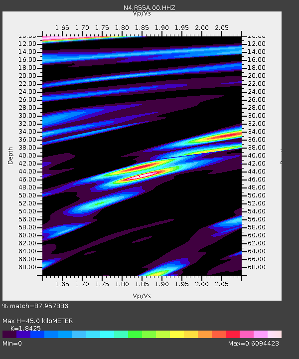
| Estimated Moho Depth: |
45.0 km |
| Estimated Crust Vp/Vs: |
1.84 |
| Assumed Crust Vp: |
6.207 km/s |
| Estimated Crust Vs: |
3.369 km/s |
| Estimated Crust Poisson's Ratio: |
0.29 |
|
| Radial Match: |
87.957886 % |
| Radial Bump: |
400 |
| Transverse Match: |
64.158165 % |
| Transverse Bump: |
400 |
| SOD ConfigId: |
28208852 |
| Insert Time: |
2022-06-27 16:12:07.331 +0000 |
| GWidth: |
2.5 |
| Max Bumps: |
400 |
| Tol: |
0.001 |
|

Signal To Noise
| Channel | StoN | STA | LTA |
| N4:R55A:00:HHZ:20220604T23:48:24.388993Z | 9.713691 | 1.3410224E-6 | 1.3805489E-7 |
| N4:R55A:00:HH1:20220604T23:48:24.388993Z | 3.3304868 | 3.8021213E-7 | 1.14161125E-7 |
| N4:R55A:00:HH2:20220604T23:48:24.388993Z | 2.6844015 | 3.1798493E-7 | 1.1845655E-7 |
| Arrivals |
| Ps | 6.3 SECOND |
| PpPs | 20 SECOND |
| PsPs/PpSs | 26 SECOND |


