You are here: Home > Network List > O2 - Oklahoma Consolidated Temporary Seismic Networks Stations List
> Station PW09 Ralston, Oklahoma > Earthquake Result Viewer
PW09 Ralston, Oklahoma - Earthquake Result Viewer
| Earthquake location: |
Rat Islands, Aleutian Islands |
| Earthquake latitude/longitude: |
52.1/178.3 |
| Earthquake time(UTC): |
2022/06/04 (155) 23:38:12 GMT |
| Earthquake Depth: |
105 km |
| Earthquake Magnitude: |
6.3 mww |
| Earthquake Catalog/Contributor: |
NEIC PDE/us |
|
| Network: |
O2 Oklahoma Consolidated Temporary Seismic Networks |
| Station: |
PW09 Ralston, Oklahoma |
| Lat/Lon: |
36.45 N/96.82 W |
| Elevation: |
291 m |
|
| Distance: |
59.4 deg |
| Az: |
68.984 deg |
| Baz: |
314.387 deg |
| Ray Param: |
0.06193871 |
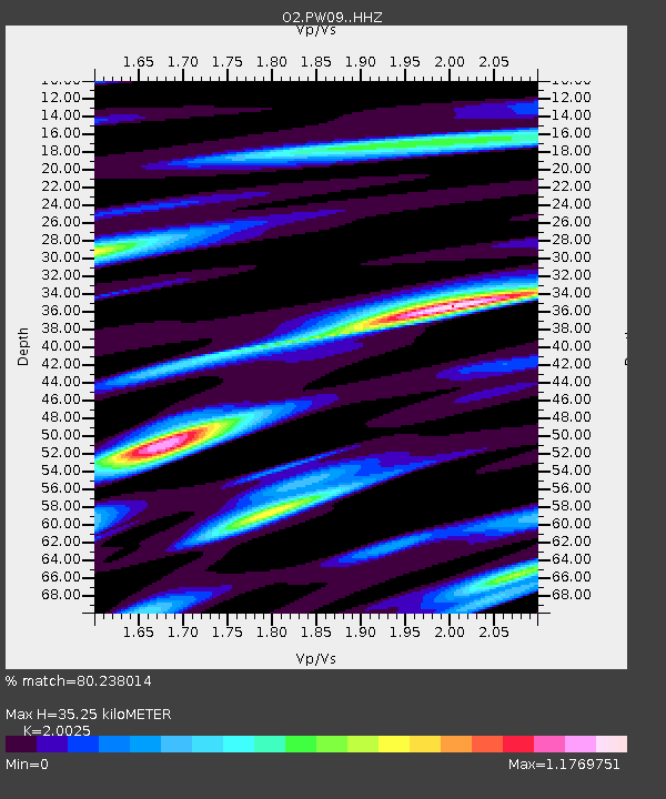
| Estimated Moho Depth: |
35.25 km |
| Estimated Crust Vp/Vs: |
2.00 |
| Assumed Crust Vp: |
6.483 km/s |
| Estimated Crust Vs: |
3.237 km/s |
| Estimated Crust Poisson's Ratio: |
0.33 |
|
| Radial Match: |
80.238014 % |
| Radial Bump: |
400 |
| Transverse Match: |
74.22276 % |
| Transverse Bump: |
400 |
| SOD ConfigId: |
28208852 |
| Insert Time: |
2022-06-27 16:15:55.173 +0000 |
| GWidth: |
2.5 |
| Max Bumps: |
400 |
| Tol: |
0.001 |
|

Signal To Noise
| Channel | StoN | STA | LTA |
| O2:PW09: :HHZ:20220604T23:47:32.885025Z | 13.169637 | 1.5690118E-6 | 1.19138576E-7 |
| O2:PW09: :HHN:20220604T23:47:32.885025Z | 2.898223 | 6.064197E-7 | 2.0923846E-7 |
| O2:PW09: :HHE:20220604T23:47:32.885025Z | 4.9115753 | 6.6961E-7 | 1.3633304E-7 |
| Arrivals |
| Ps | 5.7 SECOND |
| PpPs | 16 SECOND |
| PsPs/PpSs | 21 SECOND |


