You are here: Home > Network List > OK - Oklahoma Seismic Network Stations List
> Station MOOR Moore, Oklahoma, USA > Earthquake Result Viewer
MOOR Moore, Oklahoma, USA - Earthquake Result Viewer
| Earthquake location: |
Rat Islands, Aleutian Islands |
| Earthquake latitude/longitude: |
52.1/178.3 |
| Earthquake time(UTC): |
2022/06/04 (155) 23:38:12 GMT |
| Earthquake Depth: |
105 km |
| Earthquake Magnitude: |
6.3 mww |
| Earthquake Catalog/Contributor: |
NEIC PDE/us |
|
| Network: |
OK Oklahoma Seismic Network |
| Station: |
MOOR Moore, Oklahoma, USA |
| Lat/Lon: |
35.34 N/97.66 W |
| Elevation: |
371 m |
|
| Distance: |
59.6 deg |
| Az: |
70.454 deg |
| Baz: |
314.641 deg |
| Ray Param: |
0.061744377 |
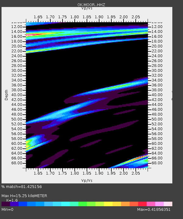
| Estimated Moho Depth: |
15.25 km |
| Estimated Crust Vp/Vs: |
1.60 |
| Assumed Crust Vp: |
6.426 km/s |
| Estimated Crust Vs: |
4.016 km/s |
| Estimated Crust Poisson's Ratio: |
0.18 |
|
| Radial Match: |
81.425156 % |
| Radial Bump: |
318 |
| Transverse Match: |
56.384594 % |
| Transverse Bump: |
400 |
| SOD ConfigId: |
28208852 |
| Insert Time: |
2022-06-27 16:17:28.309 +0000 |
| GWidth: |
2.5 |
| Max Bumps: |
400 |
| Tol: |
0.001 |
|

Signal To Noise
| Channel | StoN | STA | LTA |
| OK:MOOR: :HHZ:20220604T23:47:34.849991Z | 9.547838 | 2.6551868E-6 | 2.7809298E-7 |
| OK:MOOR: :HHN:20220604T23:47:34.849991Z | 2.8473432 | 7.595656E-7 | 2.6676292E-7 |
| OK:MOOR: :HHE:20220604T23:47:34.849991Z | 2.4955294 | 7.8848876E-7 | 3.159605E-7 |
| Arrivals |
| Ps | 1.5 SECOND |
| PpPs | 5.9 SECOND |
| PsPs/PpSs | 7.4 SECOND |


