You are here: Home > Network List > TX - Texas Seismological Network Stations List
> Station PB01 Permian Basin 1 > Earthquake Result Viewer
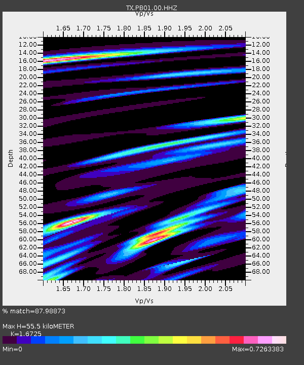
PB01 Permian Basin 1 - Earthquake Result Viewer
| Earthquake location: |
Rat Islands, Aleutian Islands |
| Earthquake latitude/longitude: |
52.1/178.3 |
| Earthquake time(UTC): |
2022/06/04 (155) 23:38:12 GMT |
| Earthquake Depth: |
105 km |
| Earthquake Magnitude: |
6.3 mww |
| Earthquake Catalog/Contributor: |
NEIC PDE/us |
|
| Network: |
TX Texas Seismological Network |
| Station: |
PB01 Permian Basin 1 |
| Lat/Lon: |
30.94 N/103.78 W |
| Elevation: |
1010 m |
|
| Distance: |
59.1 deg |
| Az: |
78.277 deg |
| Baz: |
315.296 deg |
| Ray Param: |
0.06210427 |
| Estimated Moho Depth: |
55.5 km |
| Estimated Crust Vp/Vs: |
1.67 |
| Assumed Crust Vp: |
6.121 km/s |
| Estimated Crust Vs: |
3.659 km/s |
| Estimated Crust Poisson's Ratio: |
0.22 |
|
| Radial Match: |
87.98873 % |
| Radial Bump: |
400 |
| Transverse Match: |
72.30192 % |
| Transverse Bump: |
400 |
| SOD ConfigId: |
28208852 |
| Insert Time: |
2022-06-27 16:23:59.678 +0000 |
| GWidth: |
2.5 |
| Max Bumps: |
400 |
| Tol: |
0.001 |
|

Signal To Noise
| Channel | StoN | STA | LTA |
| TX:PB01:00:HHZ:20220604T23:47:31.149979Z | 24.619884 | 1.890429E-6 | 7.678464E-8 |
| TX:PB01:00:HH1:20220604T23:47:31.149979Z | 4.8770933 | 5.602724E-7 | 1.1487834E-7 |
| TX:PB01:00:HH2:20220604T23:47:31.149979Z | 8.025762 | 8.595259E-7 | 1.0709587E-7 |
| Arrivals |
| Ps | 6.4 SECOND |
| PpPs | 23 SECOND |
| PsPs/PpSs | 30 SECOND |


