You are here: Home > Network List > TX - Texas Seismological Network Stations List
> Station PB05 Z > Earthquake Result Viewer
PB05 Z - Earthquake Result Viewer
| Earthquake location: |
Rat Islands, Aleutian Islands |
| Earthquake latitude/longitude: |
52.1/178.3 |
| Earthquake time(UTC): |
2022/06/04 (155) 23:38:12 GMT |
| Earthquake Depth: |
105 km |
| Earthquake Magnitude: |
6.3 mww |
| Earthquake Catalog/Contributor: |
NEIC PDE/us |
|
| Network: |
TX Texas Seismological Network |
| Station: |
PB05 Z |
| Lat/Lon: |
30.92 N/103.32 W |
| Elevation: |
957 m |
|
| Distance: |
59.4 deg |
| Az: |
77.972 deg |
| Baz: |
315.373 deg |
| Ray Param: |
0.061911803 |
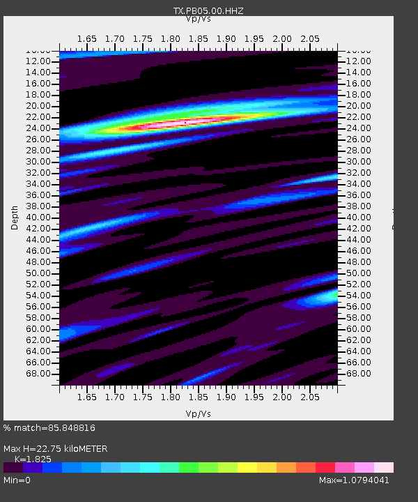
| Estimated Moho Depth: |
22.75 km |
| Estimated Crust Vp/Vs: |
1.83 |
| Assumed Crust Vp: |
6.121 km/s |
| Estimated Crust Vs: |
3.354 km/s |
| Estimated Crust Poisson's Ratio: |
0.29 |
|
| Radial Match: |
85.848816 % |
| Radial Bump: |
400 |
| Transverse Match: |
76.84499 % |
| Transverse Bump: |
400 |
| SOD ConfigId: |
28208852 |
| Insert Time: |
2022-06-27 16:24:04.271 +0000 |
| GWidth: |
2.5 |
| Max Bumps: |
400 |
| Tol: |
0.001 |
|

Signal To Noise
| Channel | StoN | STA | LTA |
| TX:PB05:00:HHZ:20220604T23:47:33.169999Z | 12.93071 | 2.0211448E-6 | 1.5630579E-7 |
| TX:PB05:00:HH1:20220604T23:47:33.169999Z | 6.902209 | 7.87857E-7 | 1.1414563E-7 |
| TX:PB05:00:HH2:20220604T23:47:33.169999Z | 4.6445036 | 4.7852586E-7 | 1.03030565E-7 |
| Arrivals |
| Ps | 3.2 SECOND |
| PpPs | 10 SECOND |
| PsPs/PpSs | 13 SECOND |


