You are here: Home > Network List > US - United States National Seismic Network Stations List
> Station AMTX Amarillo, Texas, USA > Earthquake Result Viewer
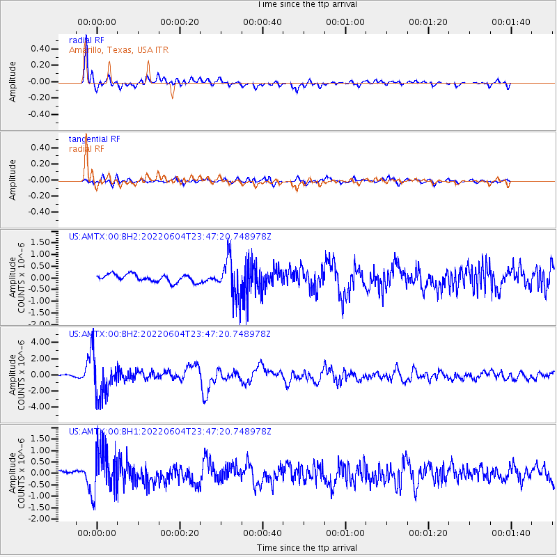
AMTX Amarillo, Texas, USA - Earthquake Result Viewer
*The percent match for this event was below the threshold and hence no stack was calculated.
| Earthquake location: |
Rat Islands, Aleutian Islands |
| Earthquake latitude/longitude: |
52.1/178.3 |
| Earthquake time(UTC): |
2022/06/04 (155) 23:38:12 GMT |
| Earthquake Depth: |
105 km |
| Earthquake Magnitude: |
6.3 mww |
| Earthquake Catalog/Contributor: |
NEIC PDE/us |
|
| Network: |
US United States National Seismic Network |
| Station: |
AMTX Amarillo, Texas, USA |
| Lat/Lon: |
34.53 N/101.41 W |
| Elevation: |
1010 m |
|
| Distance: |
58.0 deg |
| Az: |
73.649 deg |
| Baz: |
314.158 deg |
| Ray Param: |
$rayparam |
*The percent match for this event was below the threshold and hence was not used in the summary stack. |
|
| Radial Match: |
91.03527 % |
| Radial Bump: |
400 |
| Transverse Match: |
72.861404 % |
| Transverse Bump: |
400 |
| SOD ConfigId: |
28208852 |
| Insert Time: |
2022-06-27 16:26:25.605 +0000 |
| GWidth: |
2.5 |
| Max Bumps: |
400 |
| Tol: |
0.001 |
|
Signal To Noise
| Channel | StoN | STA | LTA |
| US:AMTX:00:BHZ:20220604T23:47:20.748978Z | 13.130155 | 2.2318427E-6 | 1.6997839E-7 |
| US:AMTX:00:BH1:20220604T23:47:20.748978Z | 6.606561 | 9.801549E-7 | 1.4836084E-7 |
| US:AMTX:00:BH2:20220604T23:47:20.748978Z | 5.8210826 | 9.548038E-7 | 1.6402514E-7 |
| Arrivals |
| Ps | |
| PpPs | |
| PsPs/PpSs | |


