You are here: Home > Network List > US - United States National Seismic Network Stations List
> Station RLMT Red Lodge, Montana, USA > Earthquake Result Viewer
RLMT Red Lodge, Montana, USA - Earthquake Result Viewer
| Earthquake location: |
Rat Islands, Aleutian Islands |
| Earthquake latitude/longitude: |
52.1/178.3 |
| Earthquake time(UTC): |
2022/06/04 (155) 23:38:12 GMT |
| Earthquake Depth: |
105 km |
| Earthquake Magnitude: |
6.3 mww |
| Earthquake Catalog/Contributor: |
NEIC PDE/us |
|
| Network: |
US United States National Seismic Network |
| Station: |
RLMT Red Lodge, Montana, USA |
| Lat/Lon: |
45.12 N/109.27 W |
| Elevation: |
2086 m |
|
| Distance: |
46.6 deg |
| Az: |
68.357 deg |
| Baz: |
305.863 deg |
| Ray Param: |
0.070210695 |
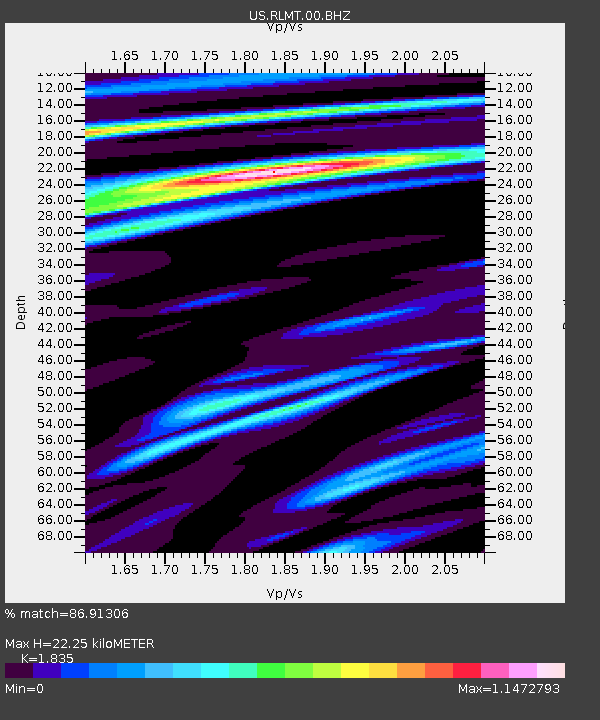
| Estimated Moho Depth: |
22.25 km |
| Estimated Crust Vp/Vs: |
1.84 |
| Assumed Crust Vp: |
6.242 km/s |
| Estimated Crust Vs: |
3.402 km/s |
| Estimated Crust Poisson's Ratio: |
0.29 |
|
| Radial Match: |
86.91306 % |
| Radial Bump: |
357 |
| Transverse Match: |
74.3863 % |
| Transverse Bump: |
400 |
| SOD ConfigId: |
28208852 |
| Insert Time: |
2022-06-27 16:27:25.699 +0000 |
| GWidth: |
2.5 |
| Max Bumps: |
400 |
| Tol: |
0.001 |
|

Signal To Noise
| Channel | StoN | STA | LTA |
| US:RLMT:00:BHZ:20220604T23:45:59.199997Z | 15.564144 | 2.3262844E-6 | 1.4946433E-7 |
| US:RLMT:00:BH1:20220604T23:45:59.199997Z | 7.93205 | 1.1178374E-6 | 1.4092667E-7 |
| US:RLMT:00:BH2:20220604T23:45:59.199997Z | 9.058303 | 9.789592E-7 | 1.0807313E-7 |
| Arrivals |
| Ps | 3.1 SECOND |
| PpPs | 9.6 SECOND |
| PsPs/PpSs | 13 SECOND |


