You are here: Home > Network List > UU - University of Utah Regional Network Stations List
> Station KNB Kanab, UT, USA > Earthquake Result Viewer
KNB Kanab, UT, USA - Earthquake Result Viewer
| Earthquake location: |
Rat Islands, Aleutian Islands |
| Earthquake latitude/longitude: |
52.1/178.3 |
| Earthquake time(UTC): |
2022/06/04 (155) 23:38:12 GMT |
| Earthquake Depth: |
105 km |
| Earthquake Magnitude: |
6.3 mww |
| Earthquake Catalog/Contributor: |
NEIC PDE/us |
|
| Network: |
UU University of Utah Regional Network |
| Station: |
KNB Kanab, UT, USA |
| Lat/Lon: |
37.02 N/112.82 W |
| Elevation: |
1715 m |
|
| Distance: |
49.5 deg |
| Az: |
79.15 deg |
| Baz: |
310.763 deg |
| Ray Param: |
0.06833997 |
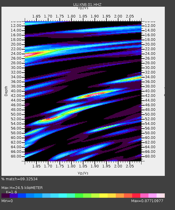
| Estimated Moho Depth: |
24.5 km |
| Estimated Crust Vp/Vs: |
1.60 |
| Assumed Crust Vp: |
6.194 km/s |
| Estimated Crust Vs: |
3.871 km/s |
| Estimated Crust Poisson's Ratio: |
0.18 |
|
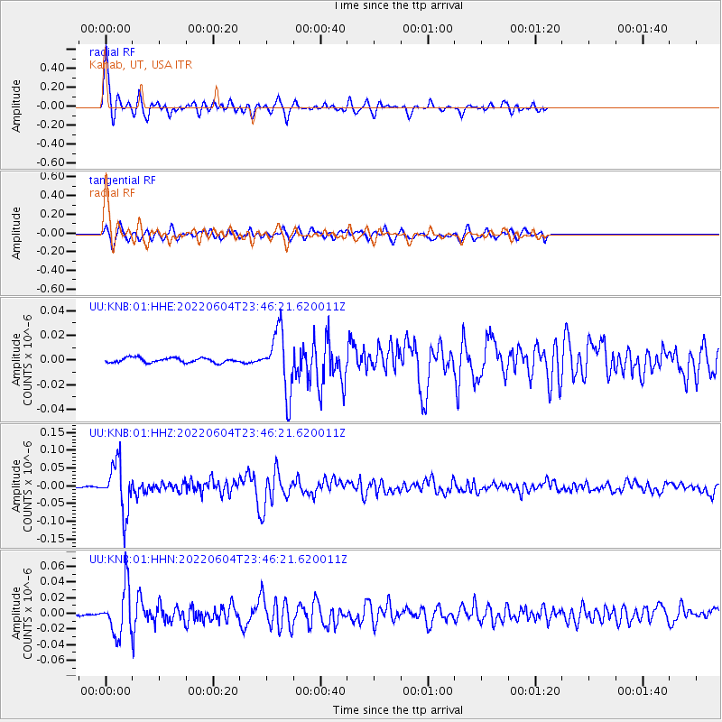
| Radial Match: |
89.32534 % |
| Radial Bump: |
400 |
| Transverse Match: |
81.08187 % |
| Transverse Bump: |
400 |
| SOD ConfigId: |
28208852 |
| Insert Time: |
2022-06-27 16:28:03.344 +0000 |
| GWidth: |
2.5 |
| Max Bumps: |
400 |
| Tol: |
0.001 |
|
Signal To Noise
| Channel | StoN | STA | LTA |
| UU:KNB:01:HHZ:20220604T23:46:21.620011Z | 42.204163 | 6.879539E-8 | 1.6300618E-9 |
| UU:KNB:01:HHN:20220604T23:46:21.620011Z | 19.473698 | 3.039088E-8 | 1.5606118E-9 |
| UU:KNB:01:HHE:20220604T23:46:21.620011Z | 13.166392 | 2.4523994E-8 | 1.8626205E-9 |
| Arrivals |
| Ps | 2.5 SECOND |
| PpPs | 9.7 SECOND |
| PsPs/PpSs | 12 SECOND |


