You are here: Home > Network List > UW - Pacific Northwest Regional Seismic Network Stations List
> Station GBB GBB, Hanford, WA, USA > Earthquake Result Viewer
GBB GBB, Hanford, WA, USA - Earthquake Result Viewer
| Earthquake location: |
Rat Islands, Aleutian Islands |
| Earthquake latitude/longitude: |
52.1/178.3 |
| Earthquake time(UTC): |
2022/06/04 (155) 23:38:12 GMT |
| Earthquake Depth: |
105 km |
| Earthquake Magnitude: |
6.3 mww |
| Earthquake Catalog/Contributor: |
NEIC PDE/us |
|
| Network: |
UW Pacific Northwest Regional Seismic Network |
| Station: |
GBB GBB, Hanford, WA, USA |
| Lat/Lon: |
46.61 N/119.63 W |
| Elevation: |
185 m |
|
| Distance: |
39.7 deg |
| Az: |
72.412 deg |
| Baz: |
301.405 deg |
| Ray Param: |
0.07447125 |
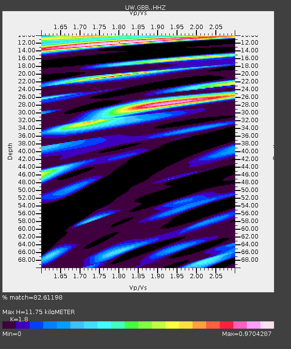
| Estimated Moho Depth: |
11.75 km |
| Estimated Crust Vp/Vs: |
1.80 |
| Assumed Crust Vp: |
6.419 km/s |
| Estimated Crust Vs: |
3.566 km/s |
| Estimated Crust Poisson's Ratio: |
0.28 |
|
| Radial Match: |
82.61198 % |
| Radial Bump: |
400 |
| Transverse Match: |
49.401775 % |
| Transverse Bump: |
400 |
| SOD ConfigId: |
28208852 |
| Insert Time: |
2022-06-27 16:29:15.411 +0000 |
| GWidth: |
2.5 |
| Max Bumps: |
400 |
| Tol: |
0.001 |
|

Signal To Noise
| Channel | StoN | STA | LTA |
| UW:GBB: :HHZ:20220604T23:45:04.180008Z | 14.03424 | 2.5917009E-6 | 1.8466984E-7 |
| UW:GBB: :HHN:20220604T23:45:04.180008Z | 5.7853107 | 7.048027E-7 | 1.2182625E-7 |
| UW:GBB: :HHE:20220604T23:45:04.180008Z | 8.918896 | 1.0135667E-6 | 1.1364262E-7 |
| Arrivals |
| Ps | 1.6 SECOND |
| PpPs | 4.8 SECOND |
| PsPs/PpSs | 6.4 SECOND |


