You are here: Home > Network List > UW - Pacific Northwest Regional Seismic Network Stations List
> Station PASS Maple Falls, WA, USA > Earthquake Result Viewer
PASS Maple Falls, WA, USA - Earthquake Result Viewer
| Earthquake location: |
Rat Islands, Aleutian Islands |
| Earthquake latitude/longitude: |
52.1/178.3 |
| Earthquake time(UTC): |
2022/06/04 (155) 23:38:12 GMT |
| Earthquake Depth: |
105 km |
| Earthquake Magnitude: |
6.3 mww |
| Earthquake Catalog/Contributor: |
NEIC PDE/us |
|
| Network: |
UW Pacific Northwest Regional Seismic Network |
| Station: |
PASS Maple Falls, WA, USA |
| Lat/Lon: |
49.00 N/122.09 W |
| Elevation: |
174 m |
|
| Distance: |
37.1 deg |
| Az: |
70.39 deg |
| Baz: |
298.005 deg |
| Ray Param: |
0.07598446 |
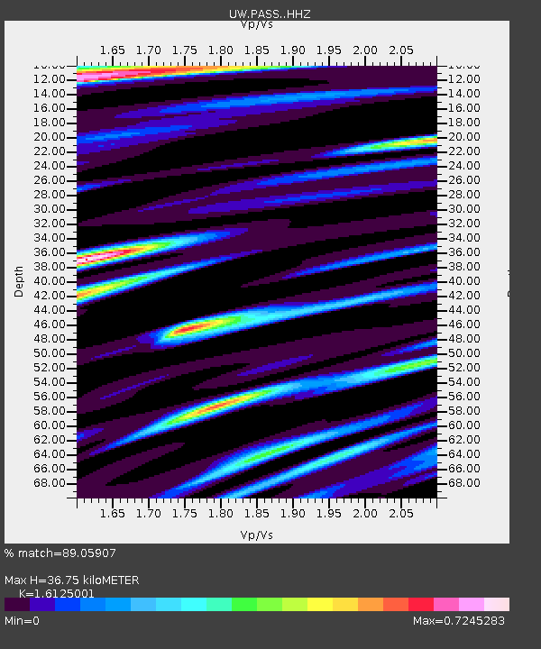
| Estimated Moho Depth: |
36.75 km |
| Estimated Crust Vp/Vs: |
1.61 |
| Assumed Crust Vp: |
6.566 km/s |
| Estimated Crust Vs: |
4.072 km/s |
| Estimated Crust Poisson's Ratio: |
0.19 |
|
| Radial Match: |
89.05907 % |
| Radial Bump: |
400 |
| Transverse Match: |
56.25122 % |
| Transverse Bump: |
400 |
| SOD ConfigId: |
28208852 |
| Insert Time: |
2022-06-27 16:30:07.783 +0000 |
| GWidth: |
2.5 |
| Max Bumps: |
400 |
| Tol: |
0.001 |
|
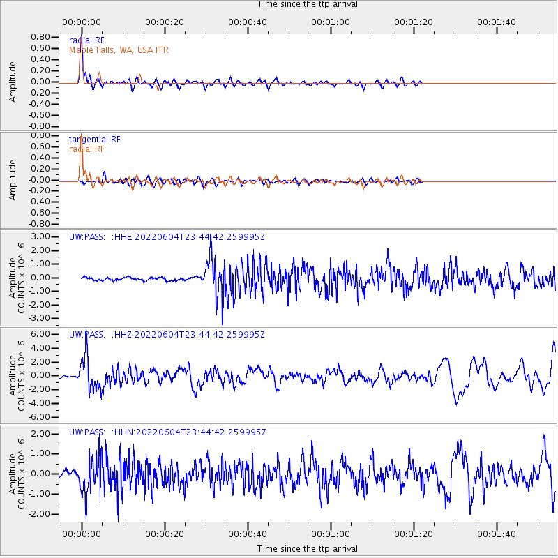
Signal To Noise
| Channel | StoN | STA | LTA |
| UW:PASS: :HHZ:20220604T23:44:42.259995Z | 15.458549 | 2.4497504E-6 | 1.584722E-7 |
| UW:PASS: :HHN:20220604T23:44:42.259995Z | 8.592761 | 8.9403994E-7 | 1.0404571E-7 |
| UW:PASS: :HHE:20220604T23:44:42.259995Z | 12.937667 | 1.3967365E-6 | 1.0795892E-7 |
| Arrivals |
| Ps | 3.7 SECOND |
| PpPs | 13 SECOND |
| PsPs/PpSs | 17 SECOND |


