You are here: Home > Network List > UW - Pacific Northwest Regional Seismic Network Stations List
> Station WYNO Wynoochee Dam Area, Olympic National Forest, WA, USA > Earthquake Result Viewer
WYNO Wynoochee Dam Area, Olympic National Forest, WA, USA - Earthquake Result Viewer
| Earthquake location: |
Rat Islands, Aleutian Islands |
| Earthquake latitude/longitude: |
52.1/178.3 |
| Earthquake time(UTC): |
2022/06/04 (155) 23:38:12 GMT |
| Earthquake Depth: |
105 km |
| Earthquake Magnitude: |
6.3 mww |
| Earthquake Catalog/Contributor: |
NEIC PDE/us |
|
| Network: |
UW Pacific Northwest Regional Seismic Network |
| Station: |
WYNO Wynoochee Dam Area, Olympic National Forest, WA, USA |
| Lat/Lon: |
47.43 N/123.61 W |
| Elevation: |
935 m |
|
| Distance: |
36.9 deg |
| Az: |
73.486 deg |
| Baz: |
299.341 deg |
| Ray Param: |
0.07606519 |
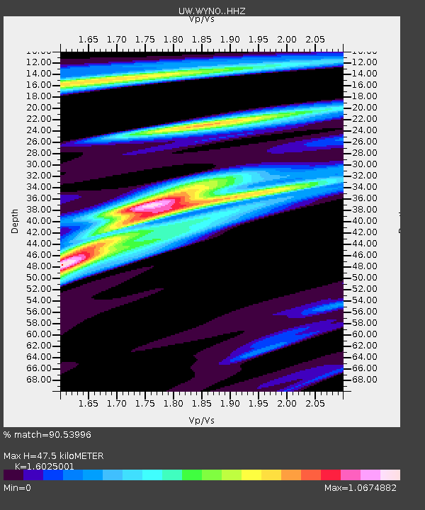
| Estimated Moho Depth: |
47.5 km |
| Estimated Crust Vp/Vs: |
1.60 |
| Assumed Crust Vp: |
6.566 km/s |
| Estimated Crust Vs: |
4.097 km/s |
| Estimated Crust Poisson's Ratio: |
0.18 |
|
| Radial Match: |
90.53996 % |
| Radial Bump: |
308 |
| Transverse Match: |
64.43121 % |
| Transverse Bump: |
400 |
| SOD ConfigId: |
28208852 |
| Insert Time: |
2022-06-27 16:30:53.229 +0000 |
| GWidth: |
2.5 |
| Max Bumps: |
400 |
| Tol: |
0.001 |
|

Signal To Noise
| Channel | StoN | STA | LTA |
| UW:WYNO: :HHZ:20220604T23:44:41.039994Z | 9.92605 | 2.3861949E-6 | 2.403972E-7 |
| UW:WYNO: :HHN:20220604T23:44:41.039994Z | 2.4435132 | 8.364069E-7 | 3.422969E-7 |
| UW:WYNO: :HHE:20220604T23:44:41.039994Z | 4.224082 | 1.2293546E-6 | 2.9103472E-7 |
| Arrivals |
| Ps | 4.7 SECOND |
| PpPs | 17 SECOND |
| PsPs/PpSs | 22 SECOND |


