You are here: Home > Network List > UW - Pacific Northwest Regional Seismic Network Stations List
> Station TBLMT Table Mt, Ellensburg, WA, USA > Earthquake Result Viewer
TBLMT Table Mt, Ellensburg, WA, USA - Earthquake Result Viewer
| Earthquake location: |
Rat Islands, Aleutian Islands |
| Earthquake latitude/longitude: |
52.1/178.3 |
| Earthquake time(UTC): |
2022/06/04 (155) 23:38:12 GMT |
| Earthquake Depth: |
105 km |
| Earthquake Magnitude: |
6.3 mww |
| Earthquake Catalog/Contributor: |
NEIC PDE/us |
|
| Network: |
UW Pacific Northwest Regional Seismic Network |
| Station: |
TBLMT Table Mt, Ellensburg, WA, USA |
| Lat/Lon: |
47.17 N/120.60 W |
| Elevation: |
1088 m |
|
| Distance: |
38.9 deg |
| Az: |
72.187 deg |
| Baz: |
300.526 deg |
| Ray Param: |
0.07497841 |
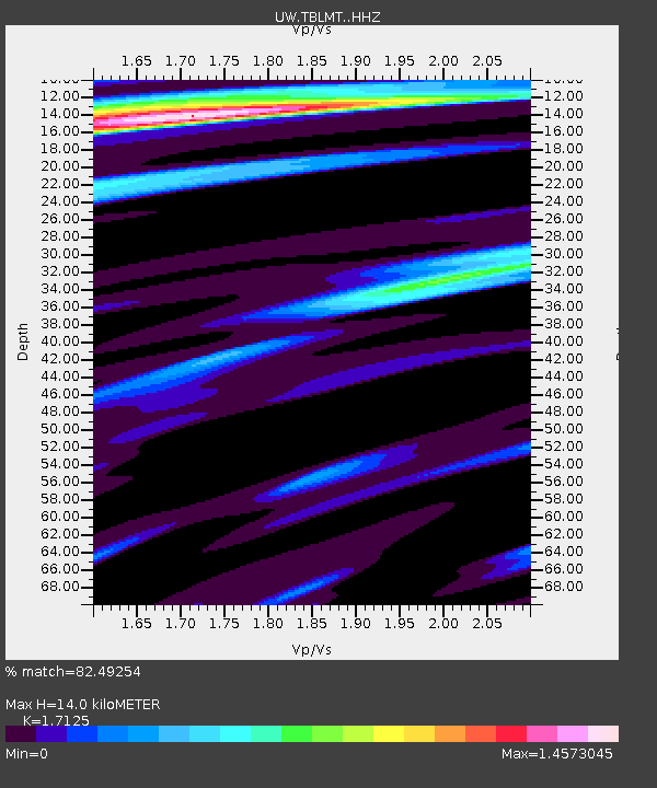
| Estimated Moho Depth: |
14.0 km |
| Estimated Crust Vp/Vs: |
1.71 |
| Assumed Crust Vp: |
6.597 km/s |
| Estimated Crust Vs: |
3.853 km/s |
| Estimated Crust Poisson's Ratio: |
0.24 |
|
| Radial Match: |
82.49254 % |
| Radial Bump: |
374 |
| Transverse Match: |
59.254208 % |
| Transverse Bump: |
400 |
| SOD ConfigId: |
28208852 |
| Insert Time: |
2022-06-27 16:31:09.188 +0000 |
| GWidth: |
2.5 |
| Max Bumps: |
400 |
| Tol: |
0.001 |
|

Signal To Noise
| Channel | StoN | STA | LTA |
| UW:TBLMT: :HHZ:20220604T23:44:57.050003Z | 12.57599 | 2.674641E-6 | 2.1267837E-7 |
| UW:TBLMT: :HHN:20220604T23:44:57.050003Z | 6.0880585 | 1.0418593E-6 | 1.711316E-7 |
| UW:TBLMT: :HHE:20220604T23:44:57.050003Z | 5.500532 | 1.4779878E-6 | 2.6869904E-7 |
| Arrivals |
| Ps | 1.6 SECOND |
| PpPs | 5.3 SECOND |
| PsPs/PpSs | 7.0 SECOND |


