You are here: Home > Network List > AK - Alaska Regional Network Stations List
> Station N15K Kwethluk River, AK, USA > Earthquake Result Viewer
N15K Kwethluk River, AK, USA - Earthquake Result Viewer
| Earthquake location: |
Minahassa Peninsula, Sulawesi |
| Earthquake latitude/longitude: |
0.1/123.7 |
| Earthquake time(UTC): |
2022/06/07 (158) 13:24:13 GMT |
| Earthquake Depth: |
132 km |
| Earthquake Magnitude: |
5.6 mww |
| Earthquake Catalog/Contributor: |
NEIC PDE/us |
|
| Network: |
AK Alaska Regional Network |
| Station: |
N15K Kwethluk River, AK, USA |
| Lat/Lon: |
60.17 N/160.09 W |
| Elevation: |
449 m |
|
| Distance: |
83.0 deg |
| Az: |
29.29 deg |
| Baz: |
258.102 deg |
| Ray Param: |
0.046169717 |
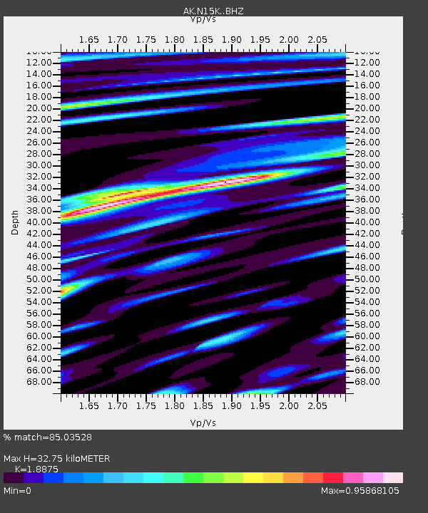
| Estimated Moho Depth: |
32.75 km |
| Estimated Crust Vp/Vs: |
1.89 |
| Assumed Crust Vp: |
6.182 km/s |
| Estimated Crust Vs: |
3.275 km/s |
| Estimated Crust Poisson's Ratio: |
0.30 |
|
| Radial Match: |
85.03528 % |
| Radial Bump: |
400 |
| Transverse Match: |
83.09076 % |
| Transverse Bump: |
400 |
| SOD ConfigId: |
28208852 |
| Insert Time: |
2022-06-27 16:48:18.616 +0000 |
| GWidth: |
2.5 |
| Max Bumps: |
400 |
| Tol: |
0.001 |
|

Signal To Noise
| Channel | StoN | STA | LTA |
| AK:N15K: :BHZ:20220607T13:35:53.580018Z | 37.24476 | 1.5634699E-6 | 4.1978254E-8 |
| AK:N15K: :BHN:20220607T13:35:53.580018Z | 4.5197167 | 2.849123E-7 | 6.3037646E-8 |
| AK:N15K: :BHE:20220607T13:35:53.580018Z | 4.997312 | 4.2115045E-7 | 8.427539E-8 |
| Arrivals |
| Ps | 4.8 SECOND |
| PpPs | 15 SECOND |
| PsPs/PpSs | 20 SECOND |


