You are here: Home > Network List > TX - Texas Seismological Network Stations List
> Station FW13 Cleburne > Earthquake Result Viewer
FW13 Cleburne - Earthquake Result Viewer
| Earthquake location: |
Northern Alaska |
| Earthquake latitude/longitude: |
69.6/-145.3 |
| Earthquake time(UTC): |
2018/08/12 (224) 14:58:54 GMT |
| Earthquake Depth: |
2.2 km |
| Earthquake Magnitude: |
6.3 ml |
| Earthquake Catalog/Contributor: |
NEIC PDE/ak |
|
| Network: |
TX Texas Seismological Network |
| Station: |
FW13 Cleburne |
| Lat/Lon: |
32.35 N/97.43 W |
| Elevation: |
259 m |
|
| Distance: |
45.7 deg |
| Az: |
118.763 deg |
| Baz: |
338.666 deg |
| Ray Param: |
0.07110731 |
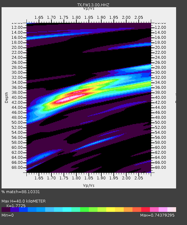
| Estimated Moho Depth: |
40.0 km |
| Estimated Crust Vp/Vs: |
1.77 |
| Assumed Crust Vp: |
6.38 km/s |
| Estimated Crust Vs: |
3.6 km/s |
| Estimated Crust Poisson's Ratio: |
0.27 |
|
| Radial Match: |
88.10331 % |
| Radial Bump: |
400 |
| Transverse Match: |
69.92893 % |
| Transverse Bump: |
400 |
| SOD ConfigId: |
2825771 |
| Insert Time: |
2018-08-26 15:06:34.756 +0000 |
| GWidth: |
2.5 |
| Max Bumps: |
400 |
| Tol: |
0.001 |
|

Signal To Noise
| Channel | StoN | STA | LTA |
| TX:FW13:00:HHZ:20180812T15:06:45.830006Z | 14.134073 | 1.3977458E-6 | 9.889193E-8 |
| TX:FW13:00:HH1:20180812T15:06:45.830006Z | 6.459073 | 3.3800225E-7 | 5.232984E-8 |
| TX:FW13:00:HH2:20180812T15:06:45.830006Z | 4.0412607 | 2.7432412E-7 | 6.788083E-8 |
| Arrivals |
| Ps | 5.2 SECOND |
| PpPs | 16 SECOND |
| PsPs/PpSs | 21 SECOND |


