You are here: Home > Network List > TX - Texas Seismological Network Stations List
> Station SGCY Sterling City > Earthquake Result Viewer
SGCY Sterling City - Earthquake Result Viewer
| Earthquake location: |
Northern Alaska |
| Earthquake latitude/longitude: |
69.6/-145.3 |
| Earthquake time(UTC): |
2018/08/12 (224) 14:58:54 GMT |
| Earthquake Depth: |
2.2 km |
| Earthquake Magnitude: |
6.3 ml |
| Earthquake Catalog/Contributor: |
NEIC PDE/ak |
|
| Network: |
TX Texas Seismological Network |
| Station: |
SGCY Sterling City |
| Lat/Lon: |
31.91 N/101.13 W |
| Elevation: |
776 m |
|
| Distance: |
45.0 deg |
| Az: |
123.099 deg |
| Baz: |
339.756 deg |
| Ray Param: |
0.07157322 |
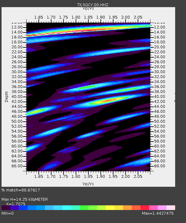
| Estimated Moho Depth: |
14.25 km |
| Estimated Crust Vp/Vs: |
1.71 |
| Assumed Crust Vp: |
6.38 km/s |
| Estimated Crust Vs: |
3.737 km/s |
| Estimated Crust Poisson's Ratio: |
0.24 |
|
| Radial Match: |
88.67617 % |
| Radial Bump: |
400 |
| Transverse Match: |
69.00405 % |
| Transverse Bump: |
400 |
| SOD ConfigId: |
2825771 |
| Insert Time: |
2018-08-26 15:06:57.436 +0000 |
| GWidth: |
2.5 |
| Max Bumps: |
400 |
| Tol: |
0.001 |
|

Signal To Noise
| Channel | StoN | STA | LTA |
| TX:SGCY:00:HHZ:20180812T15:06:40.24001Z | 7.750544 | 7.844815E-7 | 1.0121631E-7 |
| TX:SGCY:00:HH1:20180812T15:06:40.24001Z | 2.9815698 | 2.833709E-7 | 9.504083E-8 |
| TX:SGCY:00:HH2:20180812T15:06:40.24001Z | 9.249515 | 4.1404147E-7 | 4.476359E-8 |
| Arrivals |
| Ps | 1.7 SECOND |
| PpPs | 5.7 SECOND |
| PsPs/PpSs | 7.3 SECOND |


