You are here: Home > Network List > AV - Alaska Volcano Observatory Stations List
> Station MTBL Table Top, Makushin Volcano, Alaska > Earthquake Result Viewer
MTBL Table Top, Makushin Volcano, Alaska - Earthquake Result Viewer
| Earthquake location: |
Minahassa Peninsula, Sulawesi |
| Earthquake latitude/longitude: |
0.1/123.7 |
| Earthquake time(UTC): |
2022/06/07 (158) 13:24:13 GMT |
| Earthquake Depth: |
132 km |
| Earthquake Magnitude: |
5.6 mww |
| Earthquake Catalog/Contributor: |
NEIC PDE/us |
|
| Network: |
AV Alaska Volcano Observatory |
| Station: |
MTBL Table Top, Makushin Volcano, Alaska |
| Lat/Lon: |
53.97 N/166.68 W |
| Elevation: |
810 m |
|
| Distance: |
78.0 deg |
| Az: |
34.492 deg |
| Baz: |
253.43 deg |
| Ray Param: |
0.049610164 |
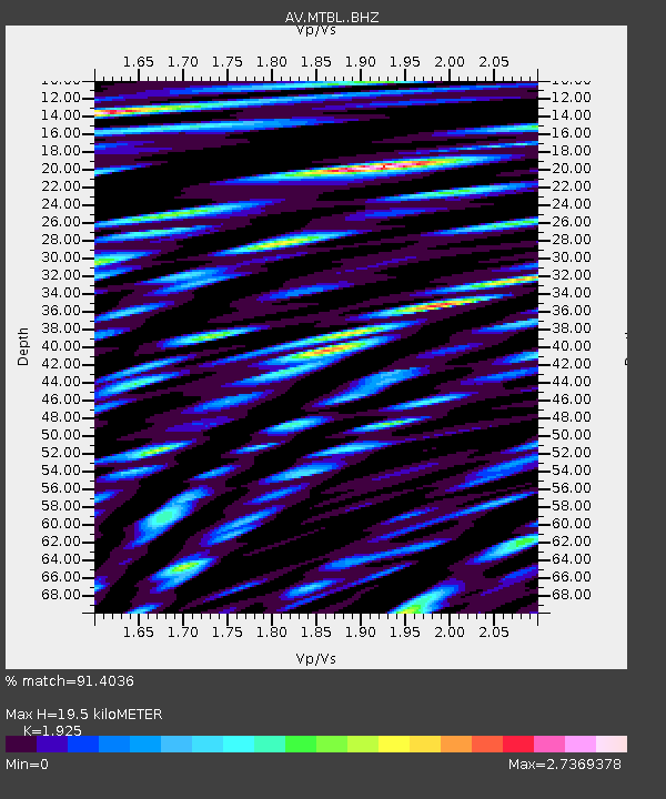
| Estimated Moho Depth: |
19.5 km |
| Estimated Crust Vp/Vs: |
1.92 |
| Assumed Crust Vp: |
3.943 km/s |
| Estimated Crust Vs: |
2.049 km/s |
| Estimated Crust Poisson's Ratio: |
0.32 |
|
| Radial Match: |
91.4036 % |
| Radial Bump: |
400 |
| Transverse Match: |
86.89131 % |
| Transverse Bump: |
400 |
| SOD ConfigId: |
28208852 |
| Insert Time: |
2022-06-27 16:51:57.377 +0000 |
| GWidth: |
2.5 |
| Max Bumps: |
400 |
| Tol: |
0.001 |
|

Signal To Noise
| Channel | StoN | STA | LTA |
| AV:MTBL: :BHZ:20220607T13:35:26.939027Z | 14.231696 | 2.2774605E-6 | 1.6002733E-7 |
| AV:MTBL: :BHN:20220607T13:35:26.939027Z | 8.81453 | 2.6221683E-6 | 2.9748247E-7 |
| AV:MTBL: :BHE:20220607T13:35:26.939027Z | 9.355756 | 2.8941101E-6 | 3.0934007E-7 |
| Arrivals |
| Ps | 4.6 SECOND |
| PpPs | 14 SECOND |
| PsPs/PpSs | 19 SECOND |


